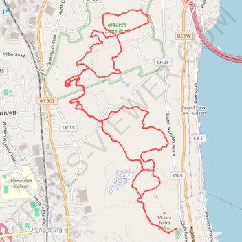
Mount Nebo to Blauvelt State Park via Long Path Green Trail
- Distance: 11.8 mi
- Elevation gain: 1,460 ft
- Maximum elevation: 656 ft
- Elevation loss: 1,463 ft
- Minimum elevation: 249 ft
- Moving time: 2 h 21 m
- Moving speed: 5.0 mph
- Maximum speed: 23.1 mph
- Total time: 2 h 39 m
- Global speed: 4.5 mph
Interactive trail map
Trail profile
- Distance: 11.8 mi
- Elevation gain: 1,460 ft
- Maximum elevation: 656 ft
- Elevation loss: 1,463 ft
- Minimum elevation: 249 ft
- Moving time: 2 h 21 m
- Moving speed: 5.0 mph
- Maximum speed: 23.1 mph
- Total time: 2 h 39 m
- Global speed: 4.5 mph
About this trail
Name: Mount Nebo to Blauvelt State Park via Long Path Green Trail trail, distance, elevation, map, profile, GPS track
Coordinates: 41.04601 -73.94590 41.07846 -73.92442
Topography: Rockland County topographic map, elevation, terrain
Other hiking, mountain biking, running and outdoor activity trails
Click on a trail to view its statistics, map and profile.
Blauvelt State Park, Buttermilk Falls Park and Schuyler Town Park loop
United States > New York > Rockland County > Blauvelt
Distance: 6.0 mi • Elevation gain: 1,132 ft • Maximum elevation: 627 ft
Rail Trail Walk, Blauvelt Orangeburg
United States > New York > Rockland County > Village of Piermont
Distance: 7.9 mi • Elevation gain: 331 ft • Maximum elevation: 197 ft
Clausland Mountain County Park loop
United States > New York > Rockland County > Blauvelt
Distance: 4.1 mi • Elevation gain: 568 ft • Maximum elevation: 656 ft
Old Croton Aqueduct Trail and Bronx
United States > New York > Westchester County > Village of Croton-on-Hudson
Distance: 44.0 mi • Elevation gain: 2,700 ft • Maximum elevation: 262 ft
Nebo Clausland Tackamac Blauvelt
United States > New York > Rockland County > Orangeburg
Distance: 11.8 mi • Elevation gain: 1,568 ft • Maximum elevation: 659 ft
Blauvelt State Park
United States > New York > Rockland County > Blauvelt
Distance: 11.7 mi • Elevation gain: 1,424 ft • Maximum elevation: 656 ft