Make a donation
Gear up for your next adventure:
As an Amazon Associate, this site earns from qualifying purchases at no extra cost to you.
2026-06-30_16-56 drumchapel
- Distance: 2.5 mi
- Elevation gain: 220 ft
- Maximum elevation: 174 ft
- Elevation loss: 220 ft
- Minimum elevation: 89 ft
- Moving time: 1 h 16 m
- Moving speed: 2.0 mph
- Maximum speed: 3.8 mph
- Total time: 1 h 22 m
- Global speed: 1.9 mph
Interactive trail map
Make a donation
Gear up for your next adventure:
As an Amazon Associate, this site earns from qualifying purchases at no extra cost to you.
Trail profile
- Distance: 2.5 mi
- Elevation gain: 220 ft
- Maximum elevation: 174 ft
- Elevation loss: 220 ft
- Minimum elevation: 89 ft
- Moving time: 1 h 16 m
- Moving speed: 2.0 mph
- Maximum speed: 3.8 mph
- Total time: 1 h 22 m
- Global speed: 1.9 mph
Make a donation
Gear up for your next adventure:
As an Amazon Associate, this site earns from qualifying purchases at no extra cost to you.
About this trail
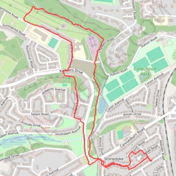
Name: 2026-06-30_16-56 drumchapel trail, distance, elevation, map, profile, GPS track
Coordinates: 55.90804 -4.35678 55.91808 -4.34268
Make a donation
Gear up for your next adventure:
As an Amazon Associate, this site earns from qualifying purchases at no extra cost to you.
Other hiking, mountain biking, running and outdoor activity trails
Click on a trail to view its statistics, map and profile.
Roads and trails in Clydebank and Drumchapel
United Kingdom > Scotland > Glasgow City > Glasgow
Distance: 7.2 mi • Elevation gain: 318 ft • Maximum elevation: 151 ft
Trails and roads in Drumchapel
United Kingdom > Scotland > East Dunbartonshire > Glasgow
Distance: 3.4 mi • Elevation gain: 240 ft • Maximum elevation: 167 ft