Make a donation
Gear up for your next adventure:
As an Amazon Associate, this site earns from qualifying purchases at no extra cost to you.
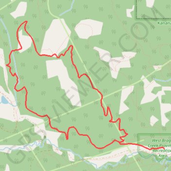
Braggin Rights to Long Distance Loop
West Bragg Creek Provincial Recreation Area. Kananaskis Country Public Land Use Zone. #Hiking #MTB #Loop #WestBraggCreek #Kananaskis
- Distance: 5.4 mi
- Elevation gain: 965 ft
- Maximum elevation: 5,367 ft
- Elevation loss: 965 ft
- Minimum elevation: 4,619 ft
Interactive trail map
Make a donation
Gear up for your next adventure:
As an Amazon Associate, this site earns from qualifying purchases at no extra cost to you.
Trail profile
- Distance: 5.4 mi
- Elevation gain: 965 ft
- Maximum elevation: 5,367 ft
- Elevation loss: 965 ft
- Minimum elevation: 4,619 ft
Make a donation
Gear up for your next adventure:
As an Amazon Associate, this site earns from qualifying purchases at no extra cost to you.
About this trail
Name: Braggin Rights to Long Distance Loop trail, distance, elevation, map, profile, GPS track
Coordinates: 50.94832 -114.72560 50.96465 -114.69360
Make a donation
Gear up for your next adventure:
As an Amazon Associate, this site earns from qualifying purchases at no extra cost to you.
Other hiking, mountain biking, running and outdoor activity trails
Click on a trail to view its statistics, map and profile.
Braggin Rights to Long Distance Loop
Canada > Alberta > Kananaskis Improvement District
Distance: 5.4 mi • Elevation gain: 965 ft • Maximum elevation: 5,367 ft
Merlin Kestrel Loop
Canada > Alberta > Kananaskis Improvement District
Distance: 9.3 mi • Elevation gain: 1,266 ft • Maximum elevation: 5,531 ft