Make a donation
Gear up for your next adventure:
As an Amazon Associate, this site earns from qualifying purchases at no extra cost to you.
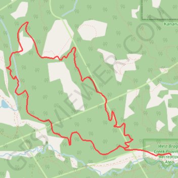
Braggin Rights to Long Distance Loop
- Distance: 5.4 mi
- Elevation gain: 965 ft
- Maximum elevation: 5,367 ft
- Elevation loss: 965 ft
- Minimum elevation: 4,619 ft
Interactive trail map
Make a donation
Gear up for your next adventure:
As an Amazon Associate, this site earns from qualifying purchases at no extra cost to you.
Trail profile
- Distance: 5.4 mi
- Elevation gain: 965 ft
- Maximum elevation: 5,367 ft
- Elevation loss: 965 ft
- Minimum elevation: 4,619 ft
Make a donation
Gear up for your next adventure:
As an Amazon Associate, this site earns from qualifying purchases at no extra cost to you.
About this trail
Name: Braggin Rights to Long Distance Loop trail, distance, elevation, map, profile, GPS track
Coordinates: 50.94832 -114.72560 50.96465 -114.69360
Make a donation
Gear up for your next adventure:
As an Amazon Associate, this site earns from qualifying purchases at no extra cost to you.
Other hiking, mountain biking, running and outdoor activity trails
Click on a trail to view its statistics, map and profile.
Braggin Rights to Long Distance Loop
Canada > Alberta > Kananaskis Improvement District
West Bragg Creek Provincial Recreation Area. Kananaskis Country Public Land Use Zone. #Hiking #MTB #Loop #WestBraggCreek #Kananaskis
Distance: 5.4 mi • Elevation gain: 965 ft • Maximum elevation: 5,367 ft
Merlin Kestrel Loop
Canada > Alberta > Kananaskis Improvement District
Distance: 9.3 mi • Elevation gain: 1,266 ft • Maximum elevation: 5,531 ft