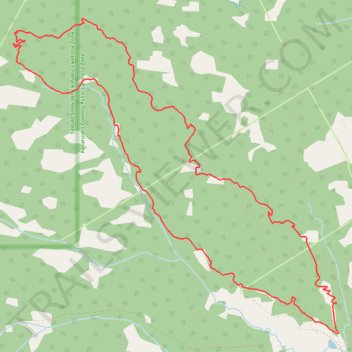
Merlin Kestrel Loop
- Distance: 9.3 mi
- Elevation gain: 1,266 ft
- Maximum elevation: 5,531 ft
- Elevation loss: 1,263 ft
- Minimum elevation: 4,849 ft
- Moving time: 47 m 5 s
- Moving speed: 11.9 mph
- Maximum speed: 23.7 mph
- Total time: 47 m 5 s
- Global speed: 11.9 mph
Interactive trail map
Trail profile
- Distance: 9.3 mi
- Elevation gain: 1,266 ft
- Maximum elevation: 5,531 ft
- Elevation loss: 1,263 ft
- Minimum elevation: 4,849 ft
- Moving time: 47 m 5 s
- Moving speed: 11.9 mph
- Maximum speed: 23.7 mph
- Total time: 47 m 5 s
- Global speed: 11.9 mph
About this trail
Name: Merlin Kestrel Loop trail, distance, elevation, map, profile, GPS track
Start: Braggin Rights, Kananaskis Improvement District, Alberta, Canada (50.95897 -114.72529)
End: Braggin Rights, Kananaskis Improvement District, Alberta, Canada (50.95907 -114.72525)
Coordinates: 50.95577 -114.78000 50.98941 -114.72490
Other hiking, mountain biking, running and outdoor activity trails
Click on a trail to view its statistics, map and profile.
Braggin Rights to Long Distance Loop
Canada > Alberta > Kananaskis Improvement District
West Bragg Creek Provincial Recreation Area. Kananaskis Country Public Land Use Zone. #Hiking #MTB #Loop #WestBraggCreek #Kananaskis
Distance: 5.4 mi • Elevation gain: 965 ft • Maximum elevation: 5,367 ft
Braggin Rights to Long Distance Loop
Canada > Alberta > Kananaskis Improvement District
Distance: 5.4 mi • Elevation gain: 965 ft • Maximum elevation: 5,367 ft