Make a donation
Gear up for your next adventure:
As an Amazon Associate, this site earns from qualifying purchases at no extra cost to you.
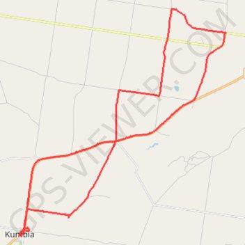
Inverlaw to Kumbia
Inverlaw, Benair, Kumbia, Queensland
- Distance: 25.3 mi
- Elevation gain: 1,102 ft
- Maximum elevation: 1,762 ft
- Elevation loss: 1,106 ft
- Minimum elevation: 1,414 ft
- Moving time: 2 h 1 m
- Moving speed: 12.5 mph
- Maximum speed: 30.1 mph
- Total time: 2 h 43 m
- Global speed: 9.3 mph
Interactive trail map
Make a donation
Gear up for your next adventure:
As an Amazon Associate, this site earns from qualifying purchases at no extra cost to you.
Trail profile
- Distance: 25.3 mi
- Elevation gain: 1,102 ft
- Maximum elevation: 1,762 ft
- Elevation loss: 1,106 ft
- Minimum elevation: 1,414 ft
- Moving time: 2 h 1 m
- Moving speed: 12.5 mph
- Maximum speed: 30.1 mph
- Total time: 2 h 43 m
- Global speed: 9.3 mph
Make a donation
Gear up for your next adventure:
As an Amazon Associate, this site earns from qualifying purchases at no extra cost to you.
About this trail
Name: Inverlaw to Kumbia trail, distance, elevation, map, profile, GPS track
Start: Wooden Hut Road, Inverlaw, South Burnett Regional, Queensland, Australia (-26.59356 151.76566)
End: Wooden Hut Road, Inverlaw, South Burnett Regional, Queensland, Australia (-26.59358 151.76563)
Coordinates: -26.69185 151.65396 -26.58193 151.76569
Make a donation
Gear up for your next adventure:
As an Amazon Associate, this site earns from qualifying purchases at no extra cost to you.
Other hiking, mountain biking, running and outdoor activity trails
Click on a trail to view its statistics, map and profile.
Goodger to Ellesmere and Archookoora State Forest
Goodger, Brooklands, Ellesmere, Haly Creek, Archookoora, Queensland
Distance: 29.7 mi • Elevation gain: 2,041 ft • Maximum elevation: 1,808 ft
Taabinga and Wattle Grove
Australia > Queensland > Kingaroy
Kingaroy, Taabinga, Inverlaw, Wattle Grove
Distance: 33.7 mi • Elevation gain: 1,555 ft • Maximum elevation: 1,778 ft
Goodger to Ellesmere
Goodger, Brooklands, Ellesmere, Haly Creek, Archookoora, Queensland
Distance: 26.6 mi • Elevation gain: 1,230 ft • Maximum elevation: 2,018 ft
Chahpingah to Kumbia
Ironpot Road
Distance: 29.8 mi • Elevation gain: 2,402 ft • Maximum elevation: 1,818 ft
Make a donation
Gear up for your next adventure:
As an Amazon Associate, this site earns from qualifying purchases at no extra cost to you.
Kumbia to Benair loop
Australia > Queensland > Kumbia
Distance: 18.9 mi • Elevation gain: 896 ft • Maximum elevation: 1,795 ft
Taabinga-Mannuem
Distance: 26.4 mi • Elevation gain: 1,345 ft • Maximum elevation: 1,791 ft