Make a donation
Gear up for your next adventure:
As an Amazon Associate, this site earns from qualifying purchases at no extra cost to you.
Tracked with OSMTracker for Android™
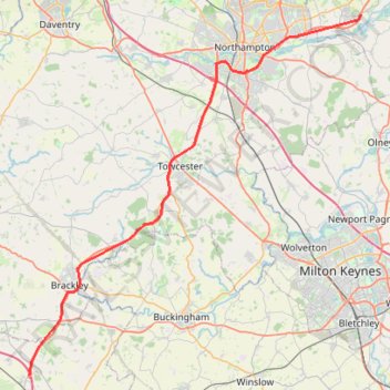
Brackley to Northampton
- Distance: 35.1 mi
- Elevation gain: 1,325 ft
- Maximum elevation: 482 ft
- Elevation loss: 1,457 ft
- Minimum elevation: 184 ft
Interactive trail map
Make a donation
Gear up for your next adventure:
As an Amazon Associate, this site earns from qualifying purchases at no extra cost to you.
Trail profile
- Distance: 35.1 mi
- Elevation gain: 1,325 ft
- Maximum elevation: 482 ft
- Elevation loss: 1,457 ft
- Minimum elevation: 184 ft
Make a donation
Gear up for your next adventure:
As an Amazon Associate, this site earns from qualifying purchases at no extra cost to you.
About this trail
Name: Tracked with OSMTracker for Android™ trail, distance, elevation, map, profile, GPS track
Coordinates: 51.94805 -1.20583 52.26623 -0.72954
Make a donation
Gear up for your next adventure:
As an Amazon Associate, this site earns from qualifying purchases at no extra cost to you.
Other hiking, mountain biking, running and outdoor activity trails
Click on a trail to view its statistics, map and profile.
The Jo Cox Way 2022 Day 3 Market Bosworth to Milton Keynes
United Kingdom > England > Leicestershire > Hinckley and Bosworth > Market Bosworth
Distance: 76.4 mi • Elevation gain: 3,127 ft • Maximum elevation: 640 ft
The Jo Cox Way 2022 Day 4 - Milton Keynes to Uxbridge
United Kingdom > England > City of Milton Keynes > Milton Keynes > Monkston
Distance: 64.9 mi • Elevation gain: 3,406 ft • Maximum elevation: 823 ft
The JCW 23 - Cranfield to Uxbridge
United Kingdom > England > Central Bedfordshire > Cranfield
Distance: 56.0 mi • Elevation gain: 2,831 ft • Maximum elevation: 873 ft
Parks and Ride Stony
United Kingdom > England > City of Milton Keynes > Milton Keynes > Wolverton
Milton Keynes Cycling
Distance: 6.1 mi • Elevation gain: 167 ft • Maximum elevation: 295 ft
Make a donation
Gear up for your next adventure:
As an Amazon Associate, this site earns from qualifying purchases at no extra cost to you.
Tracked with OSMTracker for Android™
United Kingdom > England > West Northamptonshire > Whitfield
Brackley to Oxford
Distance: 31.8 mi • Elevation gain: 738 ft • Maximum elevation: 449 ft