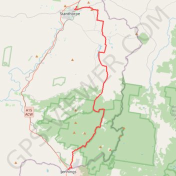
Stanthorpe - Wallangara
#Bike
- Distance: 30.2 mi
- Elevation gain: 2,218 ft
- Maximum elevation: 3,596 ft
- Elevation loss: 2,080 ft
- Minimum elevation: 2,654 ft
Interactive trail map
Trail profile
- Distance: 30.2 mi
- Elevation gain: 2,218 ft
- Maximum elevation: 3,596 ft
- Elevation loss: 2,080 ft
- Minimum elevation: 2,654 ft
About this trail
Name: Stanthorpe - Wallangara trail, distance, elevation, map, profile, GPS track
Coordinates: -28.92451 151.93124 -28.64440 152.00859
Other hiking, mountain biking, running and outdoor activity trails
Click on a trail to view its statistics, map and profile.
Wallangara - Stanthorpe
Australia > New South Wales > Jennings
#MTB
Distance: 44.0 mi • Elevation gain: 2,618 ft • Maximum elevation: 2,887 ft
Wallangara - Stanthorpe
Australia > Queensland > Wallangarra
#Bike
Distance: 34.6 mi • Elevation gain: 2,083 ft • Maximum elevation: 2,887 ft