Make a donation
Gear up for your next adventure:
As an Amazon Associate, this site earns from qualifying purchases at no extra cost to you.
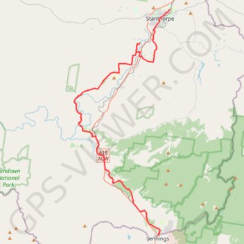
Wallangara - Stanthorpe
#Bike
- Distance: 34.6 mi
- Elevation gain: 2,083 ft
- Maximum elevation: 2,887 ft
- Elevation loss: 2,231 ft
- Minimum elevation: 2,264 ft
Interactive trail map
Make a donation
Gear up for your next adventure:
As an Amazon Associate, this site earns from qualifying purchases at no extra cost to you.
Trail profile
- Distance: 34.6 mi
- Elevation gain: 2,083 ft
- Maximum elevation: 2,887 ft
- Elevation loss: 2,231 ft
- Minimum elevation: 2,264 ft
Make a donation
Gear up for your next adventure:
As an Amazon Associate, this site earns from qualifying purchases at no extra cost to you.
About this trail
Name: Wallangara - Stanthorpe trail, distance, elevation, map, profile, GPS track
Coordinates: -28.92356 151.81306 -28.64456 151.94778
Make a donation
Gear up for your next adventure:
As an Amazon Associate, this site earns from qualifying purchases at no extra cost to you.
Other hiking, mountain biking, running and outdoor activity trails
Click on a trail to view its statistics, map and profile.
Make a donation
Gear up for your next adventure:
As an Amazon Associate, this site earns from qualifying purchases at no extra cost to you.
Wallangara - Stanthorpe
Australia > New South Wales > Jennings
#MTB
Distance: 44.0 mi • Elevation gain: 2,618 ft • Maximum elevation: 2,887 ft
Stanthorpe - Wallangara
Australia > Queensland > Stanthorpe
#Bike
Distance: 30.2 mi • Elevation gain: 2,218 ft • Maximum elevation: 3,596 ft