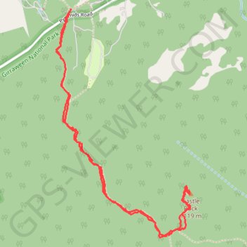
Castle Rock Track
Interactive trail map
Trail profile
- Distance: 3.3 mi
- Elevation gain: 768 ft
- Maximum elevation: 3,570 ft
- Elevation loss: 764 ft
- Minimum elevation: 2,894 ft
- Moving time: 1 h 32 m
- Moving speed: 2.1 mph
- Maximum speed: 31.6 mph
- Total time: 2 h 3 m
- Global speed: 1.6 mph
About this trail
Name: Castle Rock Track trail, distance, elevation, map, profile, GPS track
Start: Pyramids Road, Girraween, Southern Downs Regional, Queensland, Australia (-28.83253 151.93683)
End: Pyramids Road, Girraween, Southern Downs Regional, Queensland, Australia (-28.83257 151.93674)
Coordinates: -28.84633 151.93583 -28.83253 151.94505
Other hiking, mountain biking, running and outdoor activity trails
Click on a trail to view its statistics, map and profile.
Wallangara - Stanthorpe
Australia > New South Wales > Jennings
#MTB
Distance: 44.0 mi • Elevation gain: 2,618 ft • Maximum elevation: 2,887 ft
Wallangara - Stanthorpe
Australia > Queensland > Wallangarra
#Bike
Distance: 34.6 mi • Elevation gain: 2,083 ft • Maximum elevation: 2,887 ft
Stanthorpe - Wallangara
Australia > Queensland > Stanthorpe
#Bike
Distance: 30.2 mi • Elevation gain: 2,218 ft • Maximum elevation: 3,596 ft