Make a donation
Gear up for your next adventure:
As an Amazon Associate, this site earns from qualifying purchases at no extra cost to you.
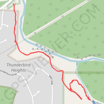
Thunderbird Falls Trail in Chugach State Park
The Thunderbird Falls Trail offers a delightful experience for hikers of all levels! As you stroll along the well-maintained path, you'll be surrounded by vibrant cottonwood and birch trees, and you'll enjoy stunning views of the breathtaking 200-foot waterfall cascading into the canyon below. Don't forget to take a detour to the creek for a closer look, where you might even be tempted to dip your toes in the refreshing waters. #Hiking #River #Waterfall #Forest #Nature
- Distance: 1.8 mi
- Elevation gain: 430 ft
- Maximum elevation: 325 ft
- Elevation loss: 430 ft
- Minimum elevation: 161 ft
- Moving time: 45 m 21 s
- Moving speed: 2.4 mph
- Maximum speed: 4.6 mph
- Total time: 1 h 15 s
- Global speed: 1.8 mph
Interactive trail map
Make a donation
Gear up for your next adventure:
As an Amazon Associate, this site earns from qualifying purchases at no extra cost to you.
Trail profile
- Distance: 1.8 mi
- Elevation gain: 430 ft
- Maximum elevation: 325 ft
- Elevation loss: 430 ft
- Minimum elevation: 161 ft
- Moving time: 45 m 21 s
- Moving speed: 2.4 mph
- Maximum speed: 4.6 mph
- Total time: 1 h 15 s
- Global speed: 1.8 mph
Make a donation
Gear up for your next adventure:
As an Amazon Associate, this site earns from qualifying purchases at no extra cost to you.
About this trail
Name: Thunderbird Falls Trail in Chugach State Park trail, distance, elevation, map, profile, GPS track
Start: Thunderbird Falls Trail, Thunderbird Heights, Anchorage, Alaska, United States (61.44907 -149.37035)
End: Thunderbird falls, Old Glenn Highway, Anchorage, Alaska, United States (61.44912 -149.37052)
Coordinates: 61.44239 -149.37052 61.44912 -149.35915
Topography: Anchorage topographic map, elevation, terrain
Make a donation
Gear up for your next adventure:
As an Amazon Associate, this site earns from qualifying purchases at no extra cost to you.
Other hiking, mountain biking, running and outdoor activity trails
Click on a trail to view its statistics, map and profile.
Road Trip Alaska 2018
United States > Alaska > Anchorage
From Anchorage.
Distance: 398.7 mi • Elevation gain: 15,719 ft • Maximum elevation: 2,425 ft