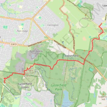
Churchill National Park, Lysterfield Park
- Distance: 6.9 mi
- Elevation gain: 1,270 ft
- Maximum elevation: 735 ft
- Elevation loss: 997 ft
- Minimum elevation: 249 ft
- Moving time: 1 h 22 m
- Moving speed: 5.0 mph
- Maximum speed: 9.7 mph
- Total time: 1 h 25 m
- Global speed: 4.8 mph
Interactive trail map
Trail profile
- Distance: 6.9 mi
- Elevation gain: 1,270 ft
- Maximum elevation: 735 ft
- Elevation loss: 997 ft
- Minimum elevation: 249 ft
- Moving time: 1 h 22 m
- Moving speed: 5.0 mph
- Maximum speed: 9.7 mph
- Total time: 1 h 25 m
- Global speed: 4.8 mph
About this trail
Name: Churchill National Park, Lysterfield Park trail, distance, elevation, map, profile, GPS track
Coordinates: -37.95131 145.25116 -37.91612 145.32521
Other hiking, mountain biking, running and outdoor activity trails
Click on a trail to view its statistics, map and profile.
Lysterfield Park MTB Loop
Australia > Victoria > Melbourne
#MTB #Loop #Lysterfield
Distance: 10.3 mi • Elevation gain: 1,247 ft • Maximum elevation: 682 ft
Lysterfield, Baluk William, Mount Morton, Birdsland
Australia > Victoria > Melbourne
Distance: 8.0 mi • Elevation gain: 1,198 ft • Maximum elevation: 876 ft
Upwey - Lysterfield Lake
Australia > Victoria > Melbourne
Distance: 15.2 mi • Elevation gain: 2,411 ft • Maximum elevation: 692 ft
Lysterfield Park
Australia > Victoria > Melbourne
Distance: 4.2 mi • Elevation gain: 686 ft • Maximum elevation: 659 ft
Churchill loop
Australia > Victoria > Melbourne
Distance: 3.8 mi • Elevation gain: 620 ft • Maximum elevation: 735 ft