Make a donation
Gear up for your next adventure:
As an Amazon Associate, this site earns from qualifying purchases at no extra cost to you.
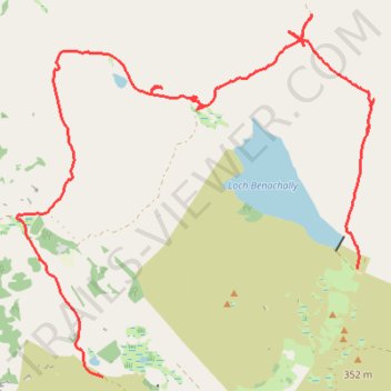
Cycle to Loch à Chait, Craigsheal and Buckinhill
- Distance: 8.0 mi
- Elevation gain: 1,010 ft
- Maximum elevation: 1,411 ft
- Elevation loss: 886 ft
- Minimum elevation: 889 ft
- Moving time: 2 h 20 m
- Moving speed: 3.4 mph
- Maximum speed: 17.9 mph
- Total time: 2 h 48 m
- Global speed: 2.8 mph
Interactive trail map
Make a donation
Gear up for your next adventure:
As an Amazon Associate, this site earns from qualifying purchases at no extra cost to you.
Trail profile
- Distance: 8.0 mi
- Elevation gain: 1,010 ft
- Maximum elevation: 1,411 ft
- Elevation loss: 886 ft
- Minimum elevation: 889 ft
- Moving time: 2 h 20 m
- Moving speed: 3.4 mph
- Maximum speed: 17.9 mph
- Total time: 2 h 48 m
- Global speed: 2.8 mph
Make a donation
Gear up for your next adventure:
As an Amazon Associate, this site earns from qualifying purchases at no extra cost to you.
About this trail
Name: Cycle to Loch à Chait, Craigsheal and Buckinhill trail, distance, elevation, map, profile, GPS track
Start: Dunkeld Road, Butterstone, Perth and Kinross, Scotland, PH8 0EU, United Kingdom (56.61684 -3.54715)
End: Buckinhill, Perth and Kinross, Scotland, PH10 7PU, United Kingdom (56.62727 -3.50230)
Coordinates: 56.61684 -3.56219 56.65189 -3.49937
Make a donation
Gear up for your next adventure:
As an Amazon Associate, this site earns from qualifying purchases at no extra cost to you.
Other hiking, mountain biking, running and outdoor activity trails
Click on a trail to view its statistics, map and profile.
Alyth to Spittal of Glenshee - Cateran Trail (some of)
United Kingdom > Scotland > Perth and Kinross > Alyth
Distance: 27.4 mi • Elevation gain: 3,720 ft • Maximum elevation: 2,133 ft
Around Loch Ordie
United Kingdom > Scotland > Perth and Kinross
Mountain Bike Ride, UK, Perthshire, Dunkeld
Distance: 22.3 mi • Elevation gain: 1,900 ft • Maximum elevation: 984 ft