Burnt Mills East
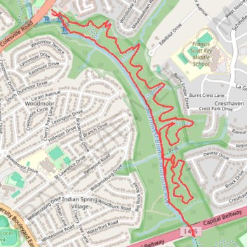
Copperhead Run Trail, Devere Loop Trail and Northwest Branch Trail.
- Distance: 4.3 mi
- Elevation gain: 577 ft
- Maximum elevation: 292 ft
- Elevation loss: 591 ft
- Minimum elevation: 184 ft
- Moving time: 1 h 54 m
- Moving speed: 2.3 mph
- Maximum speed: 6.7 mph
- Total time: 2 h 52 m
- Global speed: 1.5 mph
Interactive trail map
Trail profile
- Distance: 4.3 mi
- Elevation gain: 577 ft
- Maximum elevation: 292 ft
- Elevation loss: 591 ft
- Minimum elevation: 184 ft
- Moving time: 1 h 54 m
- Moving speed: 2.3 mph
- Maximum speed: 6.7 mph
- Total time: 2 h 52 m
- Global speed: 1.5 mph
About this trail
Name: Burnt Mills East trail, distance, elevation, map, profile, GPS track
Coordinates: 39.01708 -77.00468 39.03069 -76.99372
Topography: Montgomery County topographic map, elevation, terrain