Welch Mountain and Dickey Mountain via Welch-Dickey Loop Trail in White Mountain National Forest
The Welch-Dickey Loop Trail offers a diverse hiking experience, taking hikers through scenic woodlands, rocky outcrops, and granite slabs. As you ascend to the summits of Welch and Dickey Mountains, you'll encounter expansive views of surrounding peaks, including Sandwich Mountain, Mount Weetamoo, and parts of the Green Mountains. The trail is well-marked and enjoyable for those who appreciate a moderate challenge, with features like wild blueberries in the summer and breathtaking fall foliage, though it can be tricky in wet or icy conditions due to exposed rock surfaces. #Hiking #Loop #Mountain #Forest #Nature
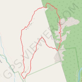
- Distance: 4.2 mi
- Elevation gain: 1,706 ft
- Maximum elevation: 2,697 ft
- Elevation loss: 1,706 ft
- Minimum elevation: 1,076 ft
- Moving time: 2 h 51 m
- Moving speed: 1.5 mph
- Maximum speed: 4.5 mph
- Total time: 3 h 52 m
- Global speed: 1.1 mph
Interactive trail map
Trail profile
- Distance: 4.2 mi
- Elevation gain: 1,706 ft
- Maximum elevation: 2,697 ft
- Elevation loss: 1,706 ft
- Minimum elevation: 1,076 ft
- Moving time: 2 h 51 m
- Moving speed: 1.5 mph
- Maximum speed: 4.5 mph
- Total time: 3 h 52 m
- Global speed: 1.1 mph
About this trail
Name: Welch Mountain and Dickey Mountain via Welch-Dickey Loop Trail in White Mountain National Forest trail, distance, elevation, map, profile, GPS track
Coordinates: 43.90465 -71.58955 43.92363 -71.57540
Topography: Grafton County topographic map, elevation, terrain
Other hiking, mountain biking, running and outdoor activity trails
Click on a trail to view its statistics, map and profile.