Welch and Dickey Mountains Loop
Interactive trail map
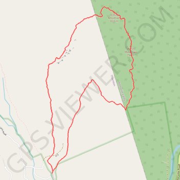
Trail profile
- Distance: 4.1 mi
- Elevation gain: 1,739 ft
- Maximum elevation: 2,697 ft
- Elevation loss: 1,739 ft
- Minimum elevation: 1,053 ft
About this trail
Name: Welch and Dickey Mountains Loop trail, distance, elevation, map, profile, GPS track
Coordinates: 43.90426 -71.58961 43.92360 -71.57543
Topography: Grafton County topographic map, elevation, terrain
Other hiking, mountain biking, running and outdoor activity trails
Click on a trail to view its statistics, map and profile.
Welch Mountain and Dickey Mountain via Welch-Dickey Loop Trail in White Mountain National Forest
United States > New Hampshire > Grafton County > Thornton
The Welch-Dickey Loop Trail offers a diverse hiking experience, taking hikers through scenic woodlands, rocky outcrops, and granite slabs. As you ascend to the summits of Welch and Dickey Mountains, you'll encounter expansive views of surrounding peaks, including Sandwich Mountain, Mount Weetamoo, and parts of…
Distance: 4.2 mi • Elevation gain: 1,706 ft • Maximum elevation: 2,697 ft