Booth Falls
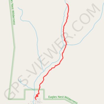
Interactive trail map
Trail profile
- Distance: 3.9 mi
- Elevation gain: 1,404 ft
- Maximum elevation: 9,810 ft
- Elevation loss: 1,404 ft
- Minimum elevation: 8,422 ft
About this trail
Name: Booth Falls trail, distance, elevation, map, profile, GPS track
Start: 3099, Booth Falls Road, Vail, Eagle County, Colorado, 81657, United States (39.65052 -106.32089)
End: 3099, Booth Falls Road, Vail, Eagle County, Colorado, 81657, United States (39.65052 -106.32089)
Coordinates: 39.65052 -106.32119 39.67299 -106.31103
Topography: Eagle County topographic map, elevation, terrain
Other hiking, mountain biking, running and outdoor activity trails
Click on a trail to view its statistics, map and profile.
Booth Falls via Booth Lake Trail in Eagles Nest Wilderness
United States > Colorado > Eagle County
The Booth Falls Trail in Vail, Colorado, offers hikers a rewarding journey through diverse landscapes, including aspen groves, alpine forests, and rocky terrains. The trail culminates at the picturesque Booth Falls, a 60-foot waterfall cascading over sandstone cliffs. Along the way, hikers can enjoy panoramic…
Distance: 4.0 mi • Elevation gain: 1,391 ft • Maximum elevation: 9,797 ft