Booth Falls via Booth Lake Trail in Eagles Nest Wilderness
The Booth Falls Trail in Vail, Colorado, offers hikers a rewarding journey through diverse landscapes, including aspen groves, alpine forests, and rocky terrains. The trail culminates at the picturesque Booth Falls, a 60-foot waterfall cascading over sandstone cliffs. Along the way, hikers can enjoy panoramic views of the Vail Valley and the Gore Range, making it a memorable experience for nature enthusiasts. #Hiking #Mountain #Forest #Nature #Waterfall
- Distance: 4.0 mi
- Elevation gain: 1,391 ft
- Maximum elevation: 9,797 ft
- Elevation loss: 1,394 ft
- Minimum elevation: 8,438 ft
- Moving time: 2 h 4 m
- Moving speed: 1.9 mph
- Maximum speed: 4.1 mph
- Total time: 2 h 42 m
- Global speed: 1.5 mph
Interactive trail map
Trail profile
- Distance: 4.0 mi
- Elevation gain: 1,391 ft
- Maximum elevation: 9,797 ft
- Elevation loss: 1,394 ft
- Minimum elevation: 8,438 ft
- Moving time: 2 h 4 m
- Moving speed: 1.9 mph
- Maximum speed: 4.1 mph
- Total time: 2 h 42 m
- Global speed: 1.5 mph
About this trail
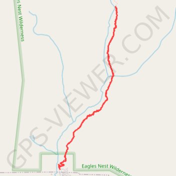
Name: Booth Falls via Booth Lake Trail in Eagles Nest Wilderness trail, distance, elevation, map, profile, GPS track
Start: Booth Lake Trail, Eagle County, Colorado, 80307, United States (39.65087 -106.32110)
End: Booth Lake Trail, Eagle County, Colorado, 80307, United States (39.65082 -106.32112)
Coordinates: 39.65082 -106.32132 39.67281 -106.31103
Topography: Eagle County topographic map, elevation, terrain
Other hiking, mountain biking, running and outdoor activity trails
Click on a trail to view its statistics, map and profile.