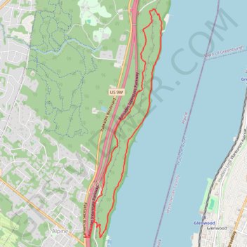
Long Path and Shore Loop in Palisades Interstate Park
This loop hike offers a captivating blend of natural beauty and rugged terrain, featuring panoramic views of the Hudson River and dramatic cliffs. Hikers can encounter diverse landscapes, including rocky descents, lush woodlands, and serene waterfronts, with spots ideal for resting and taking in the surroundings. The trail is well-marked and popular, ensuring a rewarding experience for those seeking both challenge and scenic tranquility. #Hiking #Loop #Cliff #River #Forest #Nature
- Distance: 6.1 mi
- Elevation gain: 955 ft
- Maximum elevation: 554 ft
- Elevation loss: 955 ft
- Minimum elevation: 7 ft
- Moving time: 2 h 26 m
- Moving speed: 2.5 mph
- Maximum speed: 4.5 mph
- Total time: 2 h 33 m
- Global speed: 2.4 mph
Interactive trail map
Trail profile
- Distance: 6.1 mi
- Elevation gain: 955 ft
- Maximum elevation: 554 ft
- Elevation loss: 955 ft
- Minimum elevation: 7 ft
- Moving time: 2 h 26 m
- Moving speed: 2.5 mph
- Maximum speed: 4.5 mph
- Total time: 2 h 33 m
- Global speed: 2.4 mph
About this trail
Name: Long Path and Shore Loop in Palisades Interstate Park trail, distance, elevation, map, profile, GPS track
Start: Palisades Boulevard, Alpine, Bergen County, New Jersey, 07632, United States (40.94786 -73.92288)
End: Palisades Boulevard, Alpine, Bergen County, New Jersey, 07632, United States (40.94803 -73.92292)
Coordinates: 40.94749 -73.92295 40.98256 -73.90739
Topography: Bergen County topographic map, elevation, terrain
Other hiking, mountain biking, running and outdoor activity trails
Click on a trail to view its statistics, map and profile.
State Line Lookout, White Shore, Giant Steps and Long Path Loop in Trail in Palisades Interstate Park
United States > New Jersey > Bergen County > Alpine
This loop hike offers an invigorating blend of stunning vistas and diverse terrain. Hikers can enjoy sweeping views of the Hudson River and the New York City skyline, while navigating through a variety of landscapes, including rocky outcrops and serene forest paths. Notable features along the route include the…
Distance: 4.0 mi • Elevation gain: 1,037 ft • Maximum elevation: 545 ft
Giant Stairs Palisades Loop
United States > New Jersey > Bergen County > Alpine
Distance: 4.5 mi • Elevation gain: 1,585 ft • Maximum elevation: 538 ft
Palisades Interstate Park Loop
United States > New Jersey > Bergen County > Alpine
Loop hike along the Hudson River via Long Path, Shore Trail, Peanut Leap Cascade, Giant Stairs, Blue and white Trail, State Line Lookout and Border Monument in the Palisades Interstate Park. #Hiking #Loop #River #Nature #Forest #Park #Falls #Overlook
Distance: 4.6 mi • Elevation gain: 1,283 ft • Maximum elevation: 538 ft
Palisades Loop Hike via Shore Trail and Long Path
United States > New Jersey > Bergen County > Alpine
Distance: 5.2 mi • Elevation gain: 909 ft • Maximum elevation: 456 ft
Palisades Interstate Park Mountain Bike Ride
United States > New Jersey > Bergen County > Rockleigh
Distance: 8.5 mi • Elevation gain: 1,083 ft • Maximum elevation: 531 ft
Peanut Leap Hike
United States > New Jersey > Bergen County > Alpine
Distance: 5.0 mi • Elevation gain: 1,266 ft • Maximum elevation: 541 ft
Palisades Interstate Park loop trails
United States > New Jersey > Bergen County > Alpine
Distance: 13.8 mi • Elevation gain: 1,699 ft • Maximum elevation: 561 ft
Old Croton Aqueduct Trail and Bronx
United States > New York > Westchester County > Village of Croton-on-Hudson
Distance: 44.0 mi • Elevation gain: 2,700 ft • Maximum elevation: 262 ft
Alpine & Rockleigh E-Biking
United States > New Jersey > Bergen County > Alpine
Distance: 16.2 mi • Elevation gain: 2,215 ft • Maximum elevation: 561 ft
Alpine & Rockleigh loop ride
United States > New Jersey > Bergen County > Alpine
Distance: 14.2 mi • Elevation gain: 1,804 ft • Maximum elevation: 561 ft
Alpine & Rockleigh
United States > New Jersey > Bergen County > Alpine
Palisades Interstate Park.
Distance: 9.3 mi • Elevation gain: 1,014 ft • Maximum elevation: 561 ft
Alpine & Rockleigh
United States > New Jersey > Bergen County > Alpine
Palisades Interstate Park
Distance: 12.6 mi • Elevation gain: 1,759 ft • Maximum elevation: 561 ft
Alpine & Rockleigh
United States > New Jersey > Bergen County > Alpine
Distance: 13.1 mi • Elevation gain: 1,726 ft • Maximum elevation: 561 ft
Alpine & Rockleigh
United States > New Jersey > Bergen County > Alpine
Distance: 12.4 mi • Elevation gain: 1,424 ft • Maximum elevation: 561 ft
Alpine Rockleigh
United States > New Jersey > Bergen County > Alpine
Distance: 14.7 mi • Elevation gain: 1,893 ft • Maximum elevation: 561 ft
Alpine Rockleigh
United States > New Jersey > Bergen County > Alpine
Distance: 15.3 mi • Elevation gain: 2,034 ft • Maximum elevation: 561 ft