Make a donation
Gear up for your next adventure:
As an Amazon Associate, this site earns from qualifying purchases at no extra cost to you.
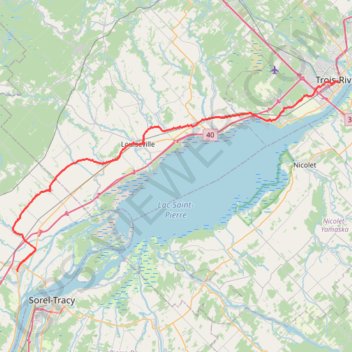
Berthierville - Trois-Rivières
#Bike
- Distance: 45.2 mi
- Elevation gain: 528 ft
- Maximum elevation: 135 ft
- Elevation loss: 531 ft
- Minimum elevation: 20 ft
Interactive trail map
Make a donation
Gear up for your next adventure:
As an Amazon Associate, this site earns from qualifying purchases at no extra cost to you.
Trail profile
- Distance: 45.2 mi
- Elevation gain: 528 ft
- Maximum elevation: 135 ft
- Elevation loss: 531 ft
- Minimum elevation: 20 ft
Make a donation
Gear up for your next adventure:
As an Amazon Associate, this site earns from qualifying purchases at no extra cost to you.
About this trail
Name: Berthierville - Trois-Rivières trail, distance, elevation, map, profile, GPS track
Coordinates: 46.08299 -73.19243 46.34032 -72.55219
Make a donation
Gear up for your next adventure:
As an Amazon Associate, this site earns from qualifying purchases at no extra cost to you.
Other hiking, mountain biking, running and outdoor activity trails
Click on a trail to view its statistics, map and profile.
Pierreville - Leclercville
Canada > Quebec > Urban agglomeration of Montreal > Montreal
#Bike #Pierreville #Leclercville #Atlantic
Distance: 75.1 mi • Elevation gain: 1,063 ft • Maximum elevation: 118 ft
Lanoraie - Trois-Rivières
Canada > Quebec > D'Autray > Lanoraie
Saint Lawrence River. #Bike #Lanoraie #TroisRivières #SaintLawrence
Distance: 44.4 mi • Elevation gain: 400 ft • Maximum elevation: 69 ft
Montréal - Berthierville
Canada > Quebec > Urban agglomeration of Montreal > Montreal
#Bike
Distance: 44.2 mi • Elevation gain: 436 ft • Maximum elevation: 135 ft
Make a donation
Gear up for your next adventure:
As an Amazon Associate, this site earns from qualifying purchases at no extra cost to you.
Trois-Rivières - Québec
Canada > Quebec > Trois-Rivières
#Bike
Distance: 86.0 mi • Elevation gain: 2,749 ft • Maximum elevation: 354 ft