Mohawk Lakes, Continental Falls and Mayflower Lake in White River National Forest
The Spruce Creek Trail in Colorado's White River National Forest offers hikers a journey through dense forests and serene meadows, leading to the tranquil Mayflower Lake. Further along, the trail ascends beside the cascading Continental Falls, providing glimpses into the area's rich mining history with remnants of old cabins and equipment. Upon reaching the picturesque Mohawk Lakes, adventurers are rewarded with expansive views of the surrounding peaks, with the dramatic backdrop of the jagged Rocky Mountains, making the challenging trek truly worthwhile. #Hiking #Mountain #Waterfall #Nature #Forest #Lake
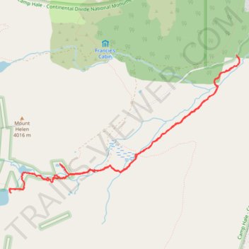
- Distance: 6.8 mi
- Elevation gain: 1,818 ft
- Maximum elevation: 12,106 ft
- Elevation loss: 1,824 ft
- Minimum elevation: 10,344 ft
- Moving time: 3 h 23 m
- Moving speed: 2.0 mph
- Maximum speed: 5.1 mph
- Total time: 5 h 2 m
- Global speed: 1.3 mph
Interactive trail map
Trail profile
- Distance: 6.8 mi
- Elevation gain: 1,818 ft
- Maximum elevation: 12,106 ft
- Elevation loss: 1,824 ft
- Minimum elevation: 10,344 ft
- Moving time: 3 h 23 m
- Moving speed: 2.0 mph
- Maximum speed: 5.1 mph
- Total time: 5 h 2 m
- Global speed: 1.3 mph
About this trail
Name: Mohawk Lakes, Continental Falls and Mayflower Lake in White River National Forest trail, distance, elevation, map, profile, GPS track
Start: Spruce Creek Trail, Summit County, Colorado, 80424, United States (39.43687 -106.05057)
End: Spruce Creek Trail, Summit County, Colorado, 80424, United States (39.43685 -106.05047)
Coordinates: 39.41856 -106.08965 39.43687 -106.05005
Topography: Summit County topographic map, elevation, terrain
Other hiking, mountain biking, running and outdoor activity trails
Click on a trail to view its statistics, map and profile.