Thank you for supporting this site ❤️
Make a donation
Make a donation
Gear up for your next adventure:
As an Amazon Associate, this site earns from qualifying purchases at no extra cost to you.
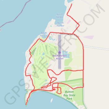
Basin Harbor trails
- Distance: 10.4 mi
- Elevation gain: 400 ft
- Maximum elevation: 177 ft
- Elevation loss: 400 ft
- Minimum elevation: 95 ft
- Moving time: 1 h 34 m
- Moving speed: 6.6 mph
- Maximum speed: 10.6 mph
- Total time: 1 h 54 m
- Global speed: 5.4 mph
Interactive trail map
Thank you for supporting this site ❤️
Make a donation
Make a donation
Gear up for your next adventure:
As an Amazon Associate, this site earns from qualifying purchases at no extra cost to you.
Trail profile
- Distance: 10.4 mi
- Elevation gain: 400 ft
- Maximum elevation: 177 ft
- Elevation loss: 400 ft
- Minimum elevation: 95 ft
- Moving time: 1 h 34 m
- Moving speed: 6.6 mph
- Maximum speed: 10.6 mph
- Total time: 1 h 54 m
- Global speed: 5.4 mph
Thank you for supporting this site ❤️
Make a donation
Make a donation
Gear up for your next adventure:
As an Amazon Associate, this site earns from qualifying purchases at no extra cost to you.
About this trail
Name: Basin Harbor trails trail, distance, elevation, map, profile, GPS track
Coordinates: 44.17844 -73.37094 44.20420 -73.35024
Topography: Addison County topographic map, elevation, terrain
Thank you for supporting this site ❤️
Make a donation
Make a donation
Gear up for your next adventure:
As an Amazon Associate, this site earns from qualifying purchases at no extra cost to you.
Other hiking, mountain biking, running and outdoor activity trails
Click on a trail to view its statistics, map and profile.