Make a donation
Gear up for your next adventure:
As an Amazon Associate, this site earns from qualifying purchases at no extra cost to you.
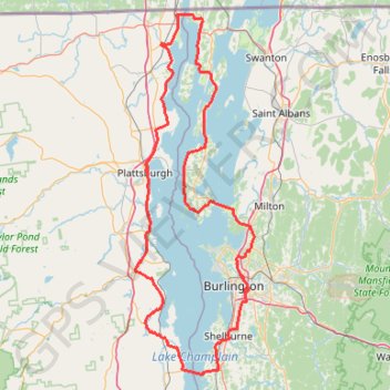
Around lake Champlain with ferry between Essex NY/Charlotte VT
- Distance: 138.4 mi
- Elevation gain: 5,715 ft
- Maximum elevation: 650 ft
- Elevation loss: 5,709 ft
- Minimum elevation: 85 ft
- Moving time: 10 h 5 m
- Moving speed: 13.7 mph
- Maximum speed: 40.2 mph
- Total time: 12 h 17 m
- Global speed: 11.3 mph
Interactive trail map
Make a donation
Gear up for your next adventure:
As an Amazon Associate, this site earns from qualifying purchases at no extra cost to you.
Trail profile
- Distance: 138.4 mi
- Elevation gain: 5,715 ft
- Maximum elevation: 650 ft
- Elevation loss: 5,709 ft
- Minimum elevation: 85 ft
- Moving time: 10 h 5 m
- Moving speed: 13.7 mph
- Maximum speed: 40.2 mph
- Total time: 12 h 17 m
- Global speed: 11.3 mph
Make a donation
Gear up for your next adventure:
As an Amazon Associate, this site earns from qualifying purchases at no extra cost to you.
About this trail
Name: Around lake Champlain with ferry between Essex NY/Charlotte VT trail, distance, elevation, map, profile, GPS track
Coordinates: 44.30090 -73.48079 44.99952 -73.15505
Topography: Chittenden County topographic map, elevation, terrain
Make a donation
Gear up for your next adventure:
As an Amazon Associate, this site earns from qualifying purchases at no extra cost to you.
Other hiking, mountain biking, running and outdoor activity trails
Click on a trail to view its statistics, map and profile.
Laplatte Nature Park Loop Trail
United States > Vermont > Chittenden County > Shelburne > Shelburne Falls
Distance: 2.4 mi • Elevation gain: 325 ft • Maximum elevation: 253 ft
Carse Natural Area Loop
United States > Vermont > Chittenden County > Charlotte
Distance: 11.1 mi • Elevation gain: 1,083 ft • Maximum elevation: 656 ft
Make a donation
Gear up for your next adventure:
As an Amazon Associate, this site earns from qualifying purchases at no extra cost to you.
Shelburne Farms Loop
United States > Vermont > Chittenden County > Shelburne
Distance: 7.1 mi • Elevation gain: 561 ft • Maximum elevation: 308 ft