Make a donation
Gear up for your next adventure:
As an Amazon Associate, this site earns from qualifying purchases at no extra cost to you.
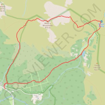
Glenmore - Meall a' Bhuachaille - Ryvoan Bothy
- Distance: 5.5 mi
- Elevation gain: 1,850 ft
- Maximum elevation: 2,648 ft
- Elevation loss: 1,818 ft
- Minimum elevation: 1,073 ft
- Moving time: 2 h 46 m
- Moving speed: 2.0 mph
- Maximum speed: 4.2 mph
- Total time: 3 h 47 m
- Global speed: 1.4 mph
Interactive trail map
Make a donation
Gear up for your next adventure:
As an Amazon Associate, this site earns from qualifying purchases at no extra cost to you.
Trail profile
- Distance: 5.5 mi
- Elevation gain: 1,850 ft
- Maximum elevation: 2,648 ft
- Elevation loss: 1,818 ft
- Minimum elevation: 1,073 ft
- Moving time: 2 h 46 m
- Moving speed: 2.0 mph
- Maximum speed: 4.2 mph
- Total time: 3 h 47 m
- Global speed: 1.4 mph
Make a donation
Gear up for your next adventure:
As an Amazon Associate, this site earns from qualifying purchases at no extra cost to you.
About this trail
Name: Glenmore - Meall a' Bhuachaille - Ryvoan Bothy trail, distance, elevation, map, profile, GPS track
Start: Cairngorm Road, Glenmore, Highland, Scotland, PH22 1QU, United Kingdom (57.16633 -3.69112)
Coordinates: 57.16633 -3.69169 57.18503 -3.64598
Make a donation
Gear up for your next adventure:
As an Amazon Associate, this site earns from qualifying purchases at no extra cost to you.
Other hiking, mountain biking, running and outdoor activity trails
Click on a trail to view its statistics, map and profile.
Cairngorms hike
United Kingdom > Scotland > Highland > Aviemore
Distance: 50.2 mi • Elevation gain: 9,846 ft • Maximum elevation: 4,304 ft
Aviemore to Loch Garten: A Tale of Trails and Trials
United Kingdom > Scotland > Highland > Aviemore
Distance: 22.0 mi • Elevation gain: 856 ft • Maximum elevation: 801 ft