Aviemore to Loch Garten: A Tale of Trails and Trials
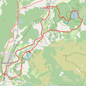
- Distance: 22.0 mi
- Elevation gain: 856 ft
- Maximum elevation: 801 ft
- Elevation loss: 856 ft
- Minimum elevation: 663 ft
- Moving time: 3 h 29 m
- Moving speed: 6.3 mph
- Maximum speed: 21.1 mph
- Total time: 4 h 27 m
- Global speed: 4.9 mph
Interactive trail map
Trail profile
- Distance: 22.0 mi
- Elevation gain: 856 ft
- Maximum elevation: 801 ft
- Elevation loss: 856 ft
- Minimum elevation: 663 ft
- Moving time: 3 h 29 m
- Moving speed: 6.3 mph
- Maximum speed: 21.1 mph
- Total time: 4 h 27 m
- Global speed: 4.9 mph
About this trail
Name: Aviemore to Loch Garten: A Tale of Trails and Trials trail, distance, elevation, map, profile, GPS track
End: B9152, Aviemore, Highland, Scotland, PH22 1PT, United Kingdom (57.18319 -3.83326)
Coordinates: 57.17698 -3.83385 57.25063 -3.68692
Other hiking, mountain biking, running and outdoor activity trails
Click on a trail to view its statistics, map and profile.
Cairngorms hike
United Kingdom > Scotland > Highland > Aviemore
Distance: 50.2 mi • Elevation gain: 9,846 ft • Maximum elevation: 4,304 ft
Glenmore - Meall a' Bhuachaille - Ryvoan Bothy
United Kingdom > Scotland > Highland > Glenmore
Distance: 5.5 mi • Elevation gain: 1,850 ft • Maximum elevation: 2,648 ft
Tracks in Docharn forest and surrounding
United Kingdom > Scotland > Highland > Grantown-on-Spey
Highlands Gravel/Unpaved Cycling
Distance: 28.2 mi • Elevation gain: 1,877 ft • Maximum elevation: 1,112 ft
Hike up Craigellachie from Aviemore
United Kingdom > Scotland > Highland > Aviemore
Distance: 3.8 mi • Elevation gain: 942 ft • Maximum elevation: 1,614 ft