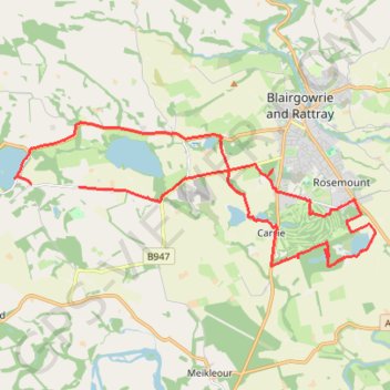
Around Blairgowrie, Scotland
Loop bike around Blairgowrie, Marlee Loch, Loch of Clunie, White Loch, Rosemount Golf Course and Stormont Loch. #Bike #Loop #Nature #Lake #Countryside #Forest
- Distance: 14.1 mi
- Elevation gain: 571 ft
- Maximum elevation: 335 ft
- Elevation loss: 630 ft
- Minimum elevation: 151 ft
- Moving time: 1 h 43 m
- Moving speed: 8.2 mph
- Maximum speed: 21.8 mph
- Total time: 2 h 11 s
- Global speed: 7.1 mph
Interactive trail map
Trail profile
- Distance: 14.1 mi
- Elevation gain: 571 ft
- Maximum elevation: 335 ft
- Elevation loss: 630 ft
- Minimum elevation: 151 ft
- Moving time: 1 h 43 m
- Moving speed: 8.2 mph
- Maximum speed: 21.8 mph
- Total time: 2 h 11 s
- Global speed: 7.1 mph
About this trail
Name: Around Blairgowrie, Scotland trail, distance, elevation, map, profile, GPS track
Start: Craigie, Perth and Kinross, Scotland, PH10 6RD, United Kingdom (56.57664 -3.41737)
End: Craigie, Perth and Kinross, Scotland, PH10 6RD, United Kingdom (56.57701 -3.43456)
Coordinates: 56.56083 -3.44046 56.58913 -3.31184
Other hiking, mountain biking, running and outdoor activity trails
Click on a trail to view its statistics, map and profile.
The Knockie, Marlee Loch and Loch of Clunie Loop
United Kingdom > Scotland > Perth and Kinross > Craigie
Loop MTB / run / hike around Blairgowrie via The Knockie, Marlee Loch and Loch of Clunie. #Hiking #Loop #Nature #Countryside #Lake
Distance: 10.7 mi • Elevation gain: 889 ft • Maximum elevation: 666 ft
Loop Gravel Ride around Blairgowrie and Rattray between Loch of Clunie and Alyth
United Kingdom > Scotland > Perth and Kinross > Newlands
Distance: 24.7 mi • Elevation gain: 1,736 ft • Maximum elevation: 922 ft
Inchtuthil Roman Legionary Fortress
United Kingdom > Scotland > Perth and Kinross > Newlands
Inchtuthil Redoubt
Distance: 8.7 mi • Elevation gain: 427 ft • Maximum elevation: 318 ft
EMTB Gravel: Murthly - Birnam - Loop
United Kingdom > Scotland > Perth and Kinross > Newlands
Around Dunkeld, Perthshire Scotland
Distance: 28.8 mi • Elevation gain: 2,851 ft • Maximum elevation: 1,001 ft
Cally Loch Mountain Bike Ride, Dunkeld
United Kingdom > Scotland > Perth and Kinross
Distance: 24.1 mi • Elevation gain: 1,985 ft • Maximum elevation: 620 ft
Mountain bike ride to Kitty Swanson's Bridge over River Ericht
United Kingdom > Scotland > Perth and Kinross > Blairgowrie and Rattray
Distance: 8.5 mi • Elevation gain: 276 ft • Maximum elevation: 230 ft
Black Hill Roman Watch Tower - Around Meikleour, Perthshire
United Kingdom > Scotland > Perth and Kinross > Newlands
Distance: 12.1 mi • Elevation gain: 807 ft • Maximum elevation: 453 ft
Mountain Bike Ride Around Clunie, Perthshire
United Kingdom > Scotland > Perth and Kinross
UK, Perthshire, Clunie
Distance: 10.4 mi • Elevation gain: 1,027 ft • Maximum elevation: 689 ft
Ninewells Kerb Cairn & Easter Cult Stones
United Kingdom > Scotland > Perth and Kinross
Around Clunie, Perthshire
Distance: 9.6 mi • Elevation gain: 922 ft • Maximum elevation: 673 ft
Ninewells Kerb Cairn
United Kingdom > Scotland > Perth and Kinross
Distance: 7.2 mi • Elevation gain: 545 ft • Maximum elevation: 469 ft
Around Meikleour
United Kingdom > Scotland > Perth and Kinross > Meikleour
Mountain Bike Ride
Distance: 4.1 mi • Elevation gain: 404 ft • Maximum elevation: 449 ft
Around Newtyle Hill, Dunkeld, Perthshire
United Kingdom > Scotland > Perth and Kinross
Distance: 17.5 mi • Elevation gain: 1,965 ft • Maximum elevation: 912 ft
Kinclaven Wood - Stanley - Bankfoot Loop
United Kingdom > Scotland > Perth and Kinross > Newlands
Distance: 26.7 mi • Elevation gain: 1,795 ft • Maximum elevation: 449 ft
Mountain Bike Ride Above Clunie
United Kingdom > Scotland > Perth and Kinross > Craigie
#UK #Perthshire #Clunie
Distance: 5.8 mi • Elevation gain: 620 ft • Maximum elevation: 620 ft
Around Blairgowrie, Scotland
United Kingdom > Scotland > Perth and Kinross > Craigie
UK, Perthshire, Blairgowrie
Distance: 12.2 mi • Elevation gain: 571 ft • Maximum elevation: 266 ft
Around Clunie, Perthshire
United Kingdom > Scotland > Perth and Kinross
Afternoon Workout. UK, Perthshire, Blairgowrie
Distance: 10.2 mi • Elevation gain: 1,014 ft • Maximum elevation: 614 ft
Around Newtyle Hill near Dunkeld
United Kingdom > Scotland > Perth and Kinross > Clunie
Distance: 15.2 mi • Elevation gain: 1,949 ft • Maximum elevation: 912 ft
Around Clunie, Perthshire
United Kingdom > Scotland > Perth and Kinross > Clunie
UK, Perthshire, Blairgowrie
Distance: 4.6 mi • Elevation gain: 499 ft • Maximum elevation: 617 ft
Mountain Bike Ride Above Clunie
United Kingdom > Scotland > Perth and Kinross
Distance: 9.4 mi • Elevation gain: 912 ft • Maximum elevation: 673 ft
Around Spittalfield, Scotland
United Kingdom > Scotland > Perth and Kinross
Distance: 11.9 mi • Elevation gain: 912 ft • Maximum elevation: 449 ft
North of Loch of Clunie
United Kingdom > Scotland > Perth and Kinross > Clunie
UK, Perthshire, Clunie
Distance: 7.6 mi • Elevation gain: 853 ft • Maximum elevation: 620 ft
Around Loch Ordie
United Kingdom > Scotland > Perth and Kinross
Mountain Bike Ride, UK, Perthshire, Dunkeld
Distance: 22.3 mi • Elevation gain: 1,900 ft • Maximum elevation: 984 ft
King's Myre Loop
United Kingdom > Scotland > Perth and Kinross > Newlands
Distance: 24.7 mi • Elevation gain: 1,198 ft • Maximum elevation: 348 ft