Thank you for supporting this site ❤️
Make a donation
Make a donation
Gear up for your next adventure:
As an Amazon Associate, this site earns from qualifying purchases at no extra cost to you.
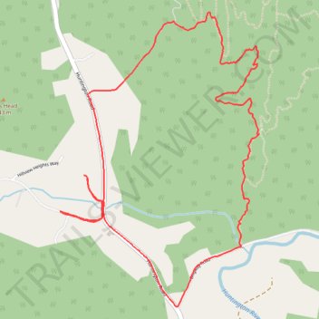
Cochrans trails
- Distance: 4.3 mi
- Elevation gain: 909 ft
- Maximum elevation: 1,270 ft
- Elevation loss: 912 ft
- Minimum elevation: 509 ft
- Moving time: 46 m 48 s
- Moving speed: 5.4 mph
- Maximum speed: 11.7 mph
- Total time: 46 m 48 s
- Global speed: 5.4 mph
Interactive trail map
Thank you for supporting this site ❤️
Make a donation
Make a donation
Gear up for your next adventure:
As an Amazon Associate, this site earns from qualifying purchases at no extra cost to you.
Trail profile
- Distance: 4.3 mi
- Elevation gain: 909 ft
- Maximum elevation: 1,270 ft
- Elevation loss: 912 ft
- Minimum elevation: 509 ft
- Moving time: 46 m 48 s
- Moving speed: 5.4 mph
- Maximum speed: 11.7 mph
- Total time: 46 m 48 s
- Global speed: 5.4 mph
Thank you for supporting this site ❤️
Make a donation
Make a donation
Gear up for your next adventure:
As an Amazon Associate, this site earns from qualifying purchases at no extra cost to you.
About this trail
Name: Cochrans trails trail, distance, elevation, map, profile, GPS track
Coordinates: 44.36250 -73.00296 44.37876 -72.98758
Topography: Chittenden County topographic map, elevation, terrain
Thank you for supporting this site ❤️
Make a donation
Make a donation
Gear up for your next adventure:
As an Amazon Associate, this site earns from qualifying purchases at no extra cost to you.
Other hiking, mountain biking, running and outdoor activity trails
Click on a trail to view its statistics, map and profile.
Joy Ride, Richmond
United States > Vermont > Chittenden County > Richmond
Distance: 7.3 mi • Elevation gain: 633 ft • Maximum elevation: 961 ft