Make a donation
Gear up for your next adventure:
As an Amazon Associate, this site earns from qualifying purchases at no extra cost to you.
Joy Ride, Richmond
- Distance: 7.3 mi
- Elevation gain: 633 ft
- Maximum elevation: 961 ft
- Elevation loss: 636 ft
- Minimum elevation: 600 ft
- Moving time: 1 h 1 m
- Moving speed: 7.1 mph
- Maximum speed: 11.9 mph
- Total time: 1 h 1 m
- Global speed: 7.1 mph
Interactive trail map
Make a donation
Gear up for your next adventure:
As an Amazon Associate, this site earns from qualifying purchases at no extra cost to you.
Trail profile
- Distance: 7.3 mi
- Elevation gain: 633 ft
- Maximum elevation: 961 ft
- Elevation loss: 636 ft
- Minimum elevation: 600 ft
- Moving time: 1 h 1 m
- Moving speed: 7.1 mph
- Maximum speed: 11.9 mph
- Total time: 1 h 1 m
- Global speed: 7.1 mph
Make a donation
Gear up for your next adventure:
As an Amazon Associate, this site earns from qualifying purchases at no extra cost to you.
About this trail
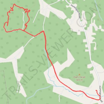
Name: Joy Ride, Richmond trail, distance, elevation, map, profile, GPS track
Coordinates: 44.36721 -73.03520 44.39257 -72.99964
Topography: Chittenden County topographic map, elevation, terrain
Make a donation
Gear up for your next adventure:
As an Amazon Associate, this site earns from qualifying purchases at no extra cost to you.
Other hiking, mountain biking, running and outdoor activity trails
Click on a trail to view its statistics, map and profile.
Cochrans trails
United States > Vermont > Chittenden County > Richmond
Distance: 4.3 mi • Elevation gain: 909 ft • Maximum elevation: 1,270 ft
Trails in Richmond along Winooski River
United States > Vermont > Chittenden County > Richmond
Distance: 9.3 mi • Elevation gain: 666 ft • Maximum elevation: 581 ft