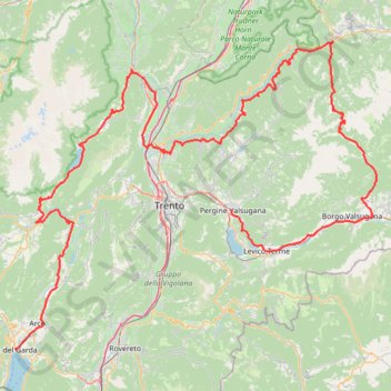
Riva del Garda - Pergine Valsugana
One-way between Riva del Garda and Pergine Valsugana.
- Distance: 120.1 mi
- Elevation gain: 18,081 ft
- Maximum elevation: 6,686 ft
- Elevation loss: 16,755 ft
- Minimum elevation: 233 ft
- Moving time: 5 h 4 m
- Moving speed: 23.7 mph
- Maximum speed: 35.9 mph
- Total time: 5 h 4 m
- Global speed: 23.7 mph
Interactive trail map
Trail profile
- Distance: 120.1 mi
- Elevation gain: 18,081 ft
- Maximum elevation: 6,686 ft
- Elevation loss: 16,755 ft
- Minimum elevation: 233 ft
- Moving time: 5 h 4 m
- Moving speed: 23.7 mph
- Maximum speed: 35.9 mph
- Total time: 5 h 4 m
- Global speed: 23.7 mph
About this trail
Name: Riva del Garda - Pergine Valsugana trail, distance, elevation, map, profile, GPS track
Coordinates: 45.88580 10.84546 46.27154 11.50127
Other hiking, mountain biking, running and outdoor activity trails
Click on a trail to view its statistics, map and profile.
Itinerario della Valsugana by PisteCiclabili.com
Italy > Trentino – Alto Adige/Südtirol > Provincia di Trento > Pergine Valsugana > Susà > Fornaci
Distance: 52.1 mi • Elevation gain: 2,687 ft • Maximum elevation: 1,617 ft
2022_DE_Bozen-Trient | flach
Italy > Trentino – Alto Adige/Südtirol > South Tyrol > Bolzano - Bozen
Distance: 40.8 mi • Elevation gain: 984 ft • Maximum elevation: 899 ft
2022_DE_Trient-Riva del Garda
Italy > Trentino – Alto Adige/Südtirol > Provincia di Trento > Trento
Distance: 31.8 mi • Elevation gain: 1,237 ft • Maximum elevation: 906 ft