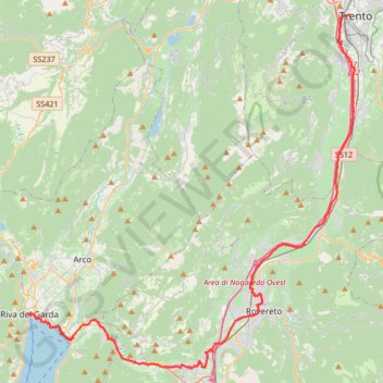
2022_DE_Trient-Riva del Garda
- Distance: 31.8 mi
- Elevation gain: 1,237 ft
- Maximum elevation: 906 ft
- Elevation loss: 1,677 ft
- Minimum elevation: 203 ft
Interactive trail map
Trail profile
- Distance: 31.8 mi
- Elevation gain: 1,237 ft
- Maximum elevation: 906 ft
- Elevation loss: 1,677 ft
- Minimum elevation: 203 ft
About this trail
Name: 2022_DE_Trient-Riva del Garda trail, distance, elevation, map, profile, GPS track
Coordinates: 45.85138 10.83902 46.06723 11.12464
Other hiking, mountain biking, running and outdoor activity trails
Click on a trail to view its statistics, map and profile.
Riva del Garda - Pergine Valsugana
Italy > Trentino – Alto Adige/Südtirol > Provincia di Trento > Riva del Garda > Sant'Alessandro > Alboletta
One-way between Riva del Garda and Pergine Valsugana.
Distance: 120.1 mi • Elevation gain: 18,081 ft • Maximum elevation: 6,686 ft
2022_DE_Bozen-Trient | flach
Italy > Trentino – Alto Adige/Südtirol > South Tyrol > Bolzano - Bozen
Distance: 40.8 mi • Elevation gain: 984 ft • Maximum elevation: 899 ft