Make a donation
Gear up for your next adventure:
As an Amazon Associate, this site earns from qualifying purchases at no extra cost to you.
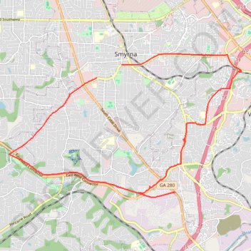
Bike ride to bus stop to go into town, then circle back along the silver comet trail and ride the newly paved part of the beltline connector
- Distance: 14.9 mi
- Elevation gain: 896 ft
- Maximum elevation: 1,093 ft
- Elevation loss: 909 ft
- Minimum elevation: 856 ft
- Moving time: 1 h 26 m
- Moving speed: 10.3 mph
- Maximum speed: 25.1 mph
- Total time: 4 h 53 m
- Global speed: 3.0 mph
Interactive trail map
Make a donation
Gear up for your next adventure:
As an Amazon Associate, this site earns from qualifying purchases at no extra cost to you.
Trail profile
- Distance: 14.9 mi
- Elevation gain: 896 ft
- Maximum elevation: 1,093 ft
- Elevation loss: 909 ft
- Minimum elevation: 856 ft
- Moving time: 1 h 26 m
- Moving speed: 10.3 mph
- Maximum speed: 25.1 mph
- Total time: 4 h 53 m
- Global speed: 3.0 mph
Make a donation
Gear up for your next adventure:
As an Amazon Associate, this site earns from qualifying purchases at no extra cost to you.
About this trail
Name: Bike ride to bus stop to go into town, then circle back along the silver comet trail and ride the newly paved part of the beltline connector trail, distance, elevation, map, profile, GPS track
Coordinates: 33.83843 -84.55901 33.88387 -84.47048
Topography: Smyrna topographic map, elevation, terrain
Make a donation
Gear up for your next adventure:
As an Amazon Associate, this site earns from qualifying purchases at no extra cost to you.
Other hiking, mountain biking, running and outdoor activity trails
Click on a trail to view its statistics, map and profile.
Ride from Smyrna to Marietta on the Mountain to River Trail
United States > Georgia > Cobb County > Smyrna
Distance: 13.6 mi • Elevation gain: 423 ft • Maximum elevation: 1,155 ft
Atlanta, Lilburn, Yellow River Park, Panola, Jonesboro
United States > Georgia > Fayette County > Peachtree City > Stop
Distance: 208.1 mi • Elevation gain: 13,314 ft • Maximum elevation: 1,109 ft
More bike ride on the Silver Comet Trail (and some other side quests)
United States > Georgia > Polk County
Distance: 47.8 mi • Elevation gain: 2,802 ft • Maximum elevation: 1,148 ft
Bike ride down the Silver Comet Trail (and some side quests)
United States > Georgia > Cobb County > Smyrna
Distance: 82.1 mi • Elevation gain: 4,278 ft • Maximum elevation: 1,152 ft
Make a donation
Gear up for your next adventure:
As an Amazon Associate, this site earns from qualifying purchases at no extra cost to you.
A Better Cobb Group Ride - Mountain to River Trail
United States > Georgia > Cobb County > Smyrna
Distance: 18.4 mi • Elevation gain: 722 ft • Maximum elevation: 1,158 ft
Bicycle ride around Smyrna, mostly on bike trails
United States > Georgia > Cobb County > Smyrna
Distance: 10.3 mi • Elevation gain: 764 ft • Maximum elevation: 1,093 ft