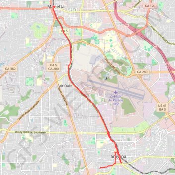
Ride from Smyrna to Marietta on the Mountain to River Trail
- Distance: 13.6 mi
- Elevation gain: 423 ft
- Maximum elevation: 1,155 ft
- Elevation loss: 430 ft
- Minimum elevation: 1,033 ft
Interactive trail map
Trail profile
- Distance: 13.6 mi
- Elevation gain: 423 ft
- Maximum elevation: 1,155 ft
- Elevation loss: 430 ft
- Minimum elevation: 1,033 ft
About this trail
Name: Ride from Smyrna to Marietta on the Mountain to River Trail trail, distance, elevation, map, profile, GPS track
Start: Atlanta Road Southeast, Smyrna, Cobb County, Georgia, 30080, United States (33.88049 -84.51293)
Coordinates: 33.87815 -84.55110 33.95281 -84.51277
Topography: Smyrna topographic map, elevation, terrain
Other hiking, mountain biking, running and outdoor activity trails
Click on a trail to view its statistics, map and profile.
Bike ride to bus stop to go into town, then circle back along the silver comet trail and ride the newly paved part of the beltline connector
United States > Georgia > Cobb County > Smyrna
Distance: 14.9 mi • Elevation gain: 896 ft • Maximum elevation: 1,093 ft
More bike ride on the Silver Comet Trail (and some other side quests)
United States > Georgia > Polk County
Distance: 47.8 mi • Elevation gain: 2,802 ft • Maximum elevation: 1,148 ft
Atlanta, Lilburn, Yellow River Park, Panola, Jonesboro
United States > Georgia > Fayette County > Peachtree City > Stop
Distance: 208.1 mi • Elevation gain: 13,314 ft • Maximum elevation: 1,109 ft
Bike ride down the Silver Comet Trail (and some side quests)
United States > Georgia > Cobb County > Smyrna
Distance: 82.1 mi • Elevation gain: 4,278 ft • Maximum elevation: 1,152 ft
A Better Cobb Group Ride - Mountain to River Trail
United States > Georgia > Cobb County > Smyrna
Distance: 18.4 mi • Elevation gain: 722 ft • Maximum elevation: 1,158 ft
Bicycle ride around Smyrna, mostly on bike trails
United States > Georgia > Cobb County > Smyrna
Distance: 10.3 mi • Elevation gain: 764 ft • Maximum elevation: 1,093 ft