Make a donation
Gear up for your next adventure:
As an Amazon Associate, this site earns from qualifying purchases at no extra cost to you.
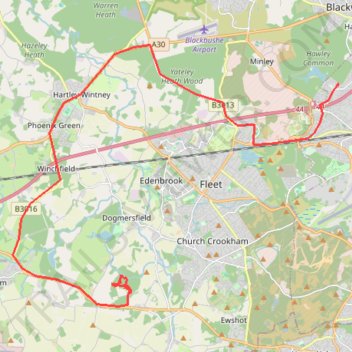
2026-06-30_10-17_Tue
- Distance: 15.7 mi
- Elevation gain: 361 ft
- Maximum elevation: 318 ft
- Elevation loss: 400 ft
- Minimum elevation: 210 ft
- Moving time: 1 h 43 m
- Moving speed: 9.2 mph
- Maximum speed: 52.9 mph
- Total time: 4 h 41 m
- Global speed: 3.4 mph
Interactive trail map
Make a donation
Gear up for your next adventure:
As an Amazon Associate, this site earns from qualifying purchases at no extra cost to you.
Trail profile
- Distance: 15.7 mi
- Elevation gain: 361 ft
- Maximum elevation: 318 ft
- Elevation loss: 400 ft
- Minimum elevation: 210 ft
- Moving time: 1 h 43 m
- Moving speed: 9.2 mph
- Maximum speed: 52.9 mph
- Total time: 4 h 41 m
- Global speed: 3.4 mph
Make a donation
Gear up for your next adventure:
As an Amazon Associate, this site earns from qualifying purchases at no extra cost to you.
About this trail
Name: 2026-06-30_10-17_Tue trail, distance, elevation, map, profile, GPS track
Coordinates: 51.24657 -0.93038 51.31987 -0.78474
Make a donation
Gear up for your next adventure:
As an Amazon Associate, this site earns from qualifying purchases at no extra cost to you.
Other hiking, mountain biking, running and outdoor activity trails
Click on a trail to view its statistics, map and profile.
Brighton Hill - South Downs National Park
United Kingdom > England > Hampshire > Basingstoke and Deane > Basingstoke
MTB loop from Brighton Hill to South Downs National Park via Upton Grey, Long Sutton, Farnham, Tilford, Holt Pound, Lodge Inclosure, Bentley, Lower Froyle and South Warnborough. #MTB #Loop #Nature #Countryside #Forest
Distance: 42.4 mi • Elevation gain: 2,999 ft • Maximum elevation: 600 ft
Basingstoke Canal from Up Nately to Odiham; near Hook, England
United Kingdom > England > Hampshire > Basingstoke and Deane > Up Nately > Andwell
Distance: 4.8 mi • Elevation gain: 177 ft • Maximum elevation: 367 ft
Minley Manor missing paths and tracks
United Kingdom > England > Hampshire > Rushmoor > Farnborough
Afternoon Ride
Distance: 3.6 mi • Elevation gain: 207 ft • Maximum elevation: 338 ft
Caesar's Bypass Cycle Route
United Kingdom > England > Hampshire > Rushmoor
Distance: 11.5 mi • Elevation gain: 515 ft • Maximum elevation: 463 ft
Make a donation
Gear up for your next adventure:
As an Amazon Associate, this site earns from qualifying purchases at no extra cost to you.
Hawley Woods Meander
United Kingdom > England > Hampshire > Rushmoor > Farnborough
Distance: 4.2 mi • Elevation gain: 184 ft • Maximum elevation: 348 ft