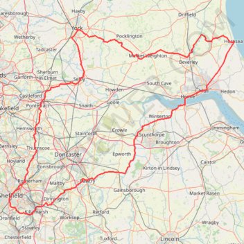
Gravel ride loop from Sheffield to Hornsea and York
- Distance: 207.1 mi
- Elevation gain: 6,024 ft
- Maximum elevation: 728 ft
- Elevation loss: 6,024 ft
- Minimum elevation: -3 ft
Interactive trail map
Trail profile
- Distance: 207.1 mi
- Elevation gain: 6,024 ft
- Maximum elevation: 728 ft
- Elevation loss: 6,024 ft
- Minimum elevation: -3 ft
About this trail
Name: Gravel ride loop from Sheffield to Hornsea and York trail, distance, elevation, map, profile, GPS track
Coordinates: 53.31283 -1.47582 53.95546 -0.16067
Other hiking, mountain biking, running and outdoor activity trails
Click on a trail to view its statistics, map and profile.
Drewton Circular
United Kingdom > England > East Riding of Yorkshire > South Cave
Distance: 4.8 mi • Elevation gain: 594 ft • Maximum elevation: 538 ft
East Riding of Yorkshire Trail Running
United Kingdom > England > East Riding of Yorkshire > Millington > Givendale
Loop run / hike from Givendale via Whitekeld Beck, Deep Dale, Millington Dale, Nettle Dale, Frendal Dale, Fenstone Quarries, Keasey Dale, Carden Dale, Coldwold Farm, Warren Farm, Wan Dale, Millington and Little Givendale Farm. #Running #Hiking #Loop #Coutryside #Nature #River #Forest
Distance: 18.7 mi • Elevation gain: 2,415 ft • Maximum elevation: 784 ft
Run from Skelton Lake to Hollinthorpe and back via the north of Swillington
United Kingdom > England > Rothwell
Uncharted territory
Distance: 9.6 mi • Elevation gain: 495 ft • Maximum elevation: 295 ft
Round Market Rasen from Lansdowne Lodge
United Kingdom > England > Lincolnshire > West Lindsey > Market Rasen
Footpaths Market Rasen
Distance: 3.2 mi • Elevation gain: 72 ft • Maximum elevation: 115 ft
Hike from Pocklington to Fridaythorpe
United Kingdom > England > East Riding of Yorkshire > York
Distance: 10.9 mi • Elevation gain: 1,545 ft • Maximum elevation: 676 ft
York Trail Running to Bilborough
United Kingdom > England > York > Copmanthorpe
Distance: 9.5 mi • Elevation gain: 253 ft • Maximum elevation: 161 ft
Loop hike in Bishop Wood
United Kingdom > England > North Yorkshire > Cawood
Distance: 4.2 mi • Elevation gain: 16 ft • Maximum elevation: 30 ft
Carlton Loop Walk
United Kingdom > England > North Yorkshire > Carlton
Distance: 4.5 mi • Elevation gain: 62 ft • Maximum elevation: 30 ft
RE SK350770 3
United Kingdom > England > Derbyshire > North East Derbyshire > Dronfield > Unstone Green
Distance: 6.0 mi • Elevation gain: 312 ft • Maximum elevation: 640 ft
RE SE910050
United Kingdom > England > North Lincolnshire > Messingham
Distance: 1.8 mi • Elevation gain: 33 ft • Maximum elevation: 72 ft
T1
United Kingdom > England > North Yorkshire > Selby
Distance: 63.9 mi • Elevation gain: 974 ft • Maximum elevation: 30 ft