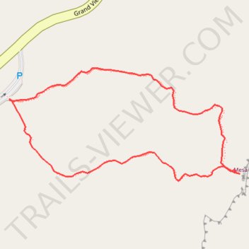
Mesa Arch Loop Trail in Canyonlands National Park
The Mesa Arch Trail in Canyonlands National Park offers hikers a brief and accessible loop leading to the stunning Mesa Arch, a natural stone arch perched at the edge of a cliff. This formation frames expansive views of the rugged canyons below and the distant La Sal Mountains. The trail's minimal elevation change and well-marked path make it suitable for all fitness levels, providing an excellent opportunity to experience the park's unique geology and panoramic vistas. #Hiking #Loop #Arch #Desert #Nature
- Distance: 0.7 mi
- Elevation gain: 92 ft
- Maximum elevation: 6,188 ft
- Elevation loss: 92 ft
- Minimum elevation: 6,109 ft
- Moving time: 17 m 18 s
- Moving speed: 2.4 mph
- Maximum speed: 3.2 mph
- Total time: 19 m 15 s
- Global speed: 2.1 mph
Interactive trail map
Trail profile
- Distance: 0.7 mi
- Elevation gain: 92 ft
- Maximum elevation: 6,188 ft
- Elevation loss: 92 ft
- Minimum elevation: 6,109 ft
- Moving time: 17 m 18 s
- Moving speed: 2.4 mph
- Maximum speed: 3.2 mph
- Total time: 19 m 15 s
- Global speed: 2.1 mph
About this trail
Name: Mesa Arch Loop Trail in Canyonlands National Park trail, distance, elevation, map, profile, GPS track
Start: Mesa Arch, Mesa Arch Loop, San Juan County, Utah, United States (38.38912 -109.86802)
End: Mesa Arch, Mesa Arch Loop, San Juan County, Utah, United States (38.38910 -109.86803)
Coordinates: 38.38787 -109.86803 38.38958 -109.86358
Topography: San Juan County topographic map, elevation, terrain
Other hiking, mountain biking, running and outdoor activity trails
Click on a trail to view its statistics, map and profile.