Make a donation
Gear up for your next adventure:
As an Amazon Associate, this site earns from qualifying purchases at no extra cost to you.
2026-04-04_13-44_Sat
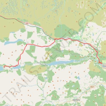
- Distance: 24.2 mi
- Elevation gain: 1,362 ft
- Maximum elevation: 1,086 ft
- Elevation loss: 1,631 ft
- Minimum elevation: 358 ft
Interactive trail map
Make a donation
Gear up for your next adventure:
As an Amazon Associate, this site earns from qualifying purchases at no extra cost to you.
Trail profile
- Distance: 24.2 mi
- Elevation gain: 1,362 ft
- Maximum elevation: 1,086 ft
- Elevation loss: 1,631 ft
- Minimum elevation: 358 ft
Make a donation
Gear up for your next adventure:
As an Amazon Associate, this site earns from qualifying purchases at no extra cost to you.
About this trail
Name: 2026-04-04_13-44_Sat trail, distance, elevation, map, profile, GPS track
Coordinates: 56.69788 -4.18736 56.77006 -3.75041
Make a donation
Gear up for your next adventure:
As an Amazon Associate, this site earns from qualifying purchases at no extra cost to you.
Other hiking, mountain biking, running and outdoor activity trails
Click on a trail to view its statistics, map and profile.
Dunfallandy Hill Loop via An Suidhe
United Kingdom > Scotland > Perth and Kinross > Pitlochry
eMTB Gravel - Pitlochry ‘Escape Route’ Cafe -> Dunfallandy Stone - Loop
Distance: 12.7 mi • Elevation gain: 1,736 ft • Maximum elevation: 1,325 ft
EMTB Gravel: Pitlochry Highlights - Loop
United Kingdom > Scotland > Perth and Kinross > Pitlochry
Distance: 10.1 mi • Elevation gain: 1,834 ft • Maximum elevation: 1,473 ft
Loop run at Craig Fonvuick
United Kingdom > Scotland > Perth and Kinross > Tenandry
Distance: 6.4 mi • Elevation gain: 1,483 ft • Maximum elevation: 1,325 ft
Circuit of Loch Errochty
United Kingdom > Scotland > Perth and Kinross > Drumcroy
Distance: 12.3 mi • Elevation gain: 1,365 ft • Maximum elevation: 1,309 ft
Make a donation
Gear up for your next adventure:
As an Amazon Associate, this site earns from qualifying purchases at no extra cost to you.
Loch Tummel Loop
United Kingdom > Scotland > Perth and Kinross > Pitlochry
To Escape Route Cafe UK, Perthshire, Loch Tummel
Distance: 28.7 mi • Elevation gain: 2,687 ft • Maximum elevation: 948 ft
Walk at Calvin and Old Struan
United Kingdom > Scotland > Perth and Kinross > Old Struan
Distance: 1.2 mi • Elevation gain: 161 ft • Maximum elevation: 630 ft
2026-04-04 Pitlochry - Kilvrecht Campsite
United Kingdom > Scotland > Perth and Kinross > Pitlochry
Distance: 30.5 mi • Elevation gain: 2,037 ft • Maximum elevation: 1,086 ft