Import a GPX file

Loop walk around St Fillans

  • Distance: 7.1 mi
  • Elevation gain: 984 ft
  • Maximum elevation: 784 ft
  • Elevation loss: 984 ft
  • Minimum elevation: 295 ft
  • Moving time: 2 h 45 m
  • Moving speed: 2.6 mph
  • Maximum speed: 20.2 mph
  • Total time: 4 h 9 m
  • Global speed: 1.7 mph

Interactive trail map

Trail profile

  • Distance: 7.1 mi
  • Elevation gain: 984 ft
  • Maximum elevation: 784 ft
  • Elevation loss: 984 ft
  • Minimum elevation: 295 ft
  • Moving time: 2 h 45 m
  • Moving speed: 2.6 mph
  • Maximum speed: 20.2 mph
  • Total time: 4 h 9 m
  • Global speed: 1.7 mph

About this trail
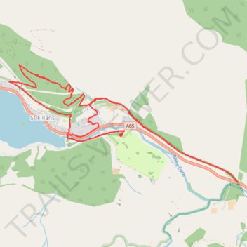
Name: Loop walk around St Fillans trail, distance, elevation, map, profile, GPS track

Start: South Loch Earn Road, St Fillans, Perth and Kinross, Scotland, PH6 2NB, United Kingdom (56.39126 -4.10525)

End: St Fillans Golf Club, A85, St Fillans, Perth and Kinross, Scotland, PH6 2NH, United Kingdom (56.39097 -4.10425)

Coordinates: 56.38601 -4.12542 56.39817 -4.08266

Other hiking, mountain biking, running and outdoor activity trails

Click on a trail to view its statistics, map and profile.

Loop Walk from St Fillans to Jerusalem in Glen Tarken

United Kingdom > Scotland > Perth and Kinross > St Fillans

Distance: 3.8 mi • Elevation gain: 650 ft • Maximum elevation: 774 ft
Munro hillwalk Meall Dearg Sgorr nam Fiannaidh Aonach Eagach

United Kingdom > Scotland > Highland

#Munro #hillwalk #Meall #Dearg #Aonach #Eagach

Distance: 107.8 mi • Elevation gain: 9,564 ft • Maximum elevation: 3,156 ft

Gear up for your next adventure:

🗺️NatGeo Topo Maps - High-quality waterproof printed topographic maps of US Parks
🧼Biodegradable Camping Soap - Eco‑friendly soap for outdoor hygiene
🛰️Handheld GPS Units - Professional satellite navigators for precise backcountry mapping
📷Action Camera - Capture your outdoor adventures in HD
🩳Quick‑Dry Hiking Shorts - Comfortable and quick‑dry shorts for summer hiking

As an Amazon Associate, this site earns from qualifying purchases at no extra cost to you.