Cascade Mountain and Porter Mountain
High Peaks Wilderness. #Hiking #Snowshoeing #Mountain #Forest #Nature
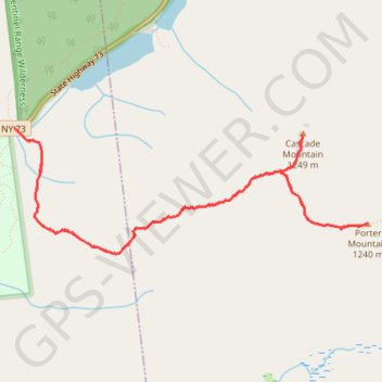
- Distance: 5.7 mi
- Elevation gain: 2,201 ft
- Maximum elevation: 4,019 ft
- Elevation loss: 2,201 ft
- Minimum elevation: 2,169 ft
Interactive trail map
Trail profile
- Distance: 5.7 mi
- Elevation gain: 2,201 ft
- Maximum elevation: 4,019 ft
- Elevation loss: 2,201 ft
- Minimum elevation: 2,169 ft
About this trail
Name: Cascade Mountain and Porter Mountain trail, distance, elevation, map, profile, GPS track
Coordinates: 44.21032 -73.88777 44.21897 -73.85395
Topography: Essex County topographic map, elevation, terrain
Other hiking, mountain biking, running and outdoor activity trails
Click on a trail to view its statistics, map and profile.
Cascade Mountain Trail to Cascade Mountain and Porter Mountain in High Peaks Wilderness
United States > New York > Essex County > Town of Keene
The hike along the Cascade Mountain Trail to both Cascade and Porter Mountains offers a rewarding experience with breathtaking views of the surrounding Adirondack peaks and Lake Champlain. The well-maintained trail features a gradual ascent with rocky sections that culminate in stunning panoramic vistas from…
Distance: 6.0 mi • Elevation gain: 2,192 ft • Maximum elevation: 4,022 ft
Cascade Mountain Trail in High Peaks Wilderness
United States > New York > Essex County > Town of Keene
The Cascade Mountain Trail in the Adirondacks offers hikers a moderately challenging ascent through dense forests, leading to a bald summit with panoramic views of the surrounding High Peaks. Along the route, hikers can observe the diverse flora of the Adirondack Park and, upon reaching the summit, enjoy…
Distance: 4.5 mi • Elevation gain: 1,854 ft • Maximum elevation: 4,022 ft