Make a donation
Gear up for your next adventure:
As an Amazon Associate, this site earns from qualifying purchases at no extra cost to you.
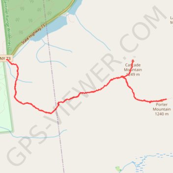
Cascade Mountain Trail to Cascade Mountain and Porter Mountain in High Peaks Wilderness
The hike along the Cascade Mountain Trail to both Cascade and Porter Mountains offers a rewarding experience with breathtaking views of the surrounding Adirondack peaks and Lake Champlain. The well-maintained trail features a gradual ascent with rocky sections that culminate in stunning panoramic vistas from the summits, making it a favorite among hikers year-round. Notably, the summit of Cascade Mountain is exposed and can be quite windy, while the slightly less popular Porter Mountain provides a unique perspective of the High Peaks region. #Hiking #Mountain #Rock #Forest #Nature
- Distance: 6.0 mi
- Elevation gain: 2,192 ft
- Maximum elevation: 4,022 ft
- Elevation loss: 2,188 ft
- Minimum elevation: 2,169 ft
- Moving time: 4 h 38 s
- Moving speed: 1.5 mph
- Maximum speed: 4.3 mph
- Total time: 6 h 23 m
- Global speed: 0.9 mph
Interactive trail map
Make a donation
Gear up for your next adventure:
As an Amazon Associate, this site earns from qualifying purchases at no extra cost to you.
Trail profile
- Distance: 6.0 mi
- Elevation gain: 2,192 ft
- Maximum elevation: 4,022 ft
- Elevation loss: 2,188 ft
- Minimum elevation: 2,169 ft
- Moving time: 4 h 38 s
- Moving speed: 1.5 mph
- Maximum speed: 4.3 mph
- Total time: 6 h 23 m
- Global speed: 0.9 mph
Make a donation
Gear up for your next adventure:
As an Amazon Associate, this site earns from qualifying purchases at no extra cost to you.
About this trail
Name: Cascade Mountain Trail to Cascade Mountain and Porter Mountain in High Peaks Wilderness trail, distance, elevation, map, profile, GPS track
Coordinates: 44.21030 -73.88756 44.21877 -73.85288
Topography: Essex County topographic map, elevation, terrain
Make a donation
Gear up for your next adventure:
As an Amazon Associate, this site earns from qualifying purchases at no extra cost to you.
Other hiking, mountain biking, running and outdoor activity trails
Click on a trail to view its statistics, map and profile.
Cascade Mountain Trail in High Peaks Wilderness
United States > New York > Essex County > Town of Keene
The Cascade Mountain Trail in the Adirondacks offers hikers a moderately challenging ascent through dense forests, leading to a bald summit with panoramic views of the surrounding High Peaks. Along the route, hikers can observe the diverse flora of the Adirondack Park and, upon reaching the summit, enjoy…
Distance: 4.5 mi • Elevation gain: 1,854 ft • Maximum elevation: 4,022 ft
Cascade Mountain and Porter Mountain
United States > New York > Essex County > Town of Keene
High Peaks Wilderness. #Hiking #Snowshoeing #Mountain #Forest #Nature
Distance: 5.7 mi • Elevation gain: 2,201 ft • Maximum elevation: 4,019 ft
Make a donation
Gear up for your next adventure:
As an Amazon Associate, this site earns from qualifying purchases at no extra cost to you.