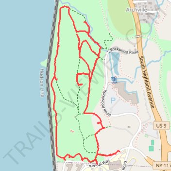
Rockwood Hall Loop
- Distance: 3.3 mi
- Elevation gain: 331 ft
- Maximum elevation: 184 ft
- Elevation loss: 335 ft
- Minimum elevation: 23 ft
- Moving time: 56 m 31 s
- Moving speed: 3.5 mph
- Maximum speed: 7.6 mph
- Total time: 59 m 23 s
- Global speed: 3.4 mph
Interactive trail map
Trail profile
- Distance: 3.3 mi
- Elevation gain: 331 ft
- Maximum elevation: 184 ft
- Elevation loss: 335 ft
- Minimum elevation: 23 ft
- Moving time: 56 m 31 s
- Moving speed: 3.5 mph
- Maximum speed: 7.6 mph
- Total time: 59 m 23 s
- Global speed: 3.4 mph
About this trail
Name: Rockwood Hall Loop trail, distance, elevation, map, profile, GPS track
Coordinates: 41.11040 -73.86836 41.12098 -73.86232
Topography: Westchester County topographic map, elevation, terrain
Other hiking, mountain biking, running and outdoor activity trails
Click on a trail to view its statistics, map and profile.
Old Croton Aqueduct Trail and Bronx
United States > New York > Westchester County > Village of Croton-on-Hudson
Distance: 44.0 mi • Elevation gain: 2,700 ft • Maximum elevation: 262 ft