Make a donation
Gear up for your next adventure:
As an Amazon Associate, this site earns from qualifying purchases at no extra cost to you.
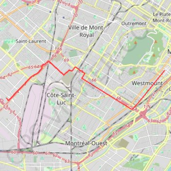
Montréal - Westmount
Interactive trail map
Make a donation
Gear up for your next adventure:
As an Amazon Associate, this site earns from qualifying purchases at no extra cost to you.
Trail profile
- Distance: 8.5 mi
- Elevation gain: 108 ft
- Maximum elevation: 197 ft
- Elevation loss: 164 ft
- Minimum elevation: 138 ft
Make a donation
Gear up for your next adventure:
As an Amazon Associate, this site earns from qualifying purchases at no extra cost to you.
About this trail
Name: Montréal - Westmount trail, distance, elevation, map, profile, GPS track
Coordinates: 45.47116 -73.70674 45.49758 -73.58284
Make a donation
Gear up for your next adventure:
As an Amazon Associate, this site earns from qualifying purchases at no extra cost to you.
Other hiking, mountain biking, running and outdoor activity trails
Click on a trail to view its statistics, map and profile.
East Hawkesbury - Montréal
Canada > Ontario > Prescott and Russell Counties > East Hawkesbury
#Bike #EastHawkesbury #Montréal
Distance: 56.8 mi • Elevation gain: 1,289 ft • Maximum elevation: 299 ft
Salaberry-de-Valleyfield - Montréal
Canada > Quebec > Beauharnois-Salaberry > Salaberry-de-Valleyfield
#Bike
Distance: 55.9 mi • Elevation gain: 1,191 ft • Maximum elevation: 230 ft
Make a donation
Gear up for your next adventure:
As an Amazon Associate, this site earns from qualifying purchases at no extra cost to you.