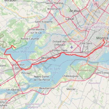
Oka - Montréal
Interactive trail map
Trail profile
- Distance: 40.6 mi
- Elevation gain: 879 ft
- Maximum elevation: 167 ft
- Elevation loss: 814 ft
- Minimum elevation: 46 ft
About this trail
Name: Oka - Montréal trail, distance, elevation, map, profile, GPS track
Start: Piste cyclable, Oka, Deux-Montagnes (MRC), Laurentides, Quebec, J7V 8P3, Canada (45.46508 -74.04161)
Coordinates: 45.38192 -74.10476 45.50018 -73.56398
Other hiking, mountain biking, running and outdoor activity trails
Click on a trail to view its statistics, map and profile.
East Hawkesbury - Montréal
Canada > Ontario > Prescott and Russell Counties > East Hawkesbury
#Bike #EastHawkesbury #Montréal
Distance: 56.8 mi • Elevation gain: 1,289 ft • Maximum elevation: 299 ft
Salaberry-de-Valleyfield - Montréal
Canada > Quebec > Beauharnois-Salaberry > Salaberry-de-Valleyfield
#Bike
Distance: 55.9 mi • Elevation gain: 1,191 ft • Maximum elevation: 230 ft
Arboretum Morgan Yellow Trail
Canada > Quebec > Urban agglomeration of Montreal > Sainte-Anne-de-Bellevue
#Hiking #Snowshoeing #Ski
Distance: 2.8 mi • Elevation gain: 108 ft • Maximum elevation: 184 ft
Pierreville - Leclercville
Canada > Quebec > Urban agglomeration of Montreal > Montreal
#Bike #Pierreville #Leclercville #Atlantic
Distance: 75.1 mi • Elevation gain: 1,063 ft • Maximum elevation: 118 ft
Montréal - Lanoraie
Canada > Quebec > Urban agglomeration of Montreal > Montreal
Saint Lawrence River. #Bike #Montréal #Lanoraie #SaintLawrence
Distance: 43.6 mi • Elevation gain: 594 ft • Maximum elevation: 171 ft