Upper Yosemite Fall Trail via Columbia Rock and Oh My Gosh Point
The Upper Yosemite Fall Trail is a rewarding yet challenging hike that offers some of the best panoramic views in Yosemite National Park. Climbing steep switchbacks, you'll pass Columbia Rock for breathtaking sights of Yosemite Valley and continue toward Oh My Gosh Point, where the dramatic view of the falls will leave you in awe. The strenuous effort is more than worth it, with each step offering closer glimpses of Half Dome, Sentinel Dome, and, of course, the stunning Yosemite Falls. #Hiking #Mountain #River #Waterfall #Forest #Nature #Yosemite #Rock
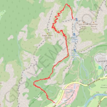
- Distance: 7.4 mi
- Elevation gain: 4,902 ft
- Maximum elevation: 6,693 ft
- Elevation loss: 4,902 ft
- Minimum elevation: 4,012 ft
- Moving time: 4 h 55 m
- Moving speed: 1.5 mph
- Maximum speed: 7.2 mph
- Total time: 6 h 42 m
- Global speed: 1.1 mph
Interactive trail map
Trail profile
- Distance: 7.4 mi
- Elevation gain: 4,902 ft
- Maximum elevation: 6,693 ft
- Elevation loss: 4,902 ft
- Minimum elevation: 4,012 ft
- Moving time: 4 h 55 m
- Moving speed: 1.5 mph
- Maximum speed: 7.2 mph
- Total time: 6 h 42 m
- Global speed: 1.1 mph
About this trail
Name: Upper Yosemite Fall Trail via Columbia Rock and Oh My Gosh Point trail, distance, elevation, map, profile, GPS track
Coordinates: 37.74204 -119.60642 37.75971 -119.59746
Topography: Mariposa County topographic map, elevation, terrain
Other hiking, mountain biking, running and outdoor activity trails
Click on a trail to view its statistics, map and profile.
Upper Yosemite Fall, Yosemite Point, Oh My Gosh Point and Columbia Rock
United States > California > Mariposa County > Yosemite Village > Yosemite Lodge
Starting near Yosemite Lodge and the Camp Four area, this demanding route climbs the Upper Yosemite Fall Trail through oak woodland and granite switchbacks, quickly rising above Yosemite Valley toward Columbia Rock, where broad views open over the valley floor, Merced River corridor, Half Dome, and surrounding…
Distance: 9.3 mi • Elevation gain: 7,995 ft • Maximum elevation: 7,031 ft
Columbia Rock
United States > California > Mariposa County > Yosemite Village > Yosemite Lodge
From the Yosemite Valley near Camp Four, the Upper Yosemite Fall Trail climbs steadily into the forest, following a long series of switchbacks above the valley floor. The route reaches Columbia Rock, a rocky overlook with a broad panorama over Yosemite Valley, Half Dome, Sentinel Rock and the surrounding…
Distance: 1.0 mi • Elevation gain: 1,171 ft • Maximum elevation: 5,023 ft
Yosemite Valley Loop
United States > California > Mariposa County > Yosemite Village
From Yosemite Village, the route slips into the Valley Loop Trail corridor, moving through the quieter village edge toward Yosemite Falls views before continuing west below the Three Brothers and into the open floor of Leidig Meadow, where forest, meadow grass, and the Merced River alternate along the way. The…
Distance: 9.2 mi • Elevation gain: 699 ft • Maximum elevation: 4,068 ft
Columbia Rock Trail via Upper Yosemite Fall Trail in Yosemite National Park
United States > California > Mariposa County > Yosemite Village > Yosemite Lodge
The Columbia Rock Trail, accessible via the Upper Yosemite Fall Trail, offers hikers a rewarding ascent through oak woodlands and granite switchbacks. Upon reaching Columbia Rock, you're greeted with panoramic views of Yosemite Valley, including iconic landmarks like Half Dome and Sentinel Rock. For those…
Distance: 1.9 mi • Elevation gain: 1,211 ft • Maximum elevation: 5,023 ft
Yosemite Point via Upper Yosemite Fall Trail in Yosemite National Park
United States > California > Mariposa County > Yosemite Lodge
The Upper Yosemite Falls Trail to Yosemite Point is a strenuous hike that offers hikers panoramic views of Yosemite Valley, including iconic landmarks such as Half Dome and the Cathedral Spires. Along the ascent, the trail provides close-up perspectives of the majestic Upper Yosemite Falls—one of the tallest…
Distance: 8.6 mi • Elevation gain: 5,823 ft • Maximum elevation: 7,014 ft
Yosemite North Dome Loop
United States > California > Mariposa County > Curry Village
Loop hike to North Dome via Lower Mirror Lake, Tenaya Creek, Valley Loop Trail, Snow Creek Trail, North Dome Trail, Upper Yosemite Fall Trail, Oh My Gosh Point and Columbia Rock in the Yosemite National Park. #Hiking #Loop #Mountain #Nature #Lake #Forest #Fall #Park #Yosemite
Distance: 19.9 mi • Elevation gain: 7,464 ft • Maximum elevation: 8,150 ft
Upper Yosemite Fall Trail in Yosemite National Park
United States > California > Mariposa County > Yosemite Village > Yosemite Lodge
The Upper Yosemite Fall Trail is a demanding hike that rewards adventurers with breathtaking panoramic views of Yosemite Valley, Half Dome, and the mighty Yosemite Falls. As you ascend, you'll pass through diverse terrain, from oak forests and steep switchbacks to open sections offering sweeping vistas. The…
Distance: 6.3 mi • Elevation gain: 4,925 ft • Maximum elevation: 6,690 ft