Black Duck
- Distance: 28.4 mi
- Elevation gain: 2,057 ft
- Maximum elevation: 1,867 ft
- Elevation loss: 2,421 ft
- Minimum elevation: 725 ft
- Moving time: 2 h 35 m
- Moving speed: 10.9 mph
- Maximum speed: 46.4 mph
- Total time: 6 h 26 m
- Global speed: 4.4 mph
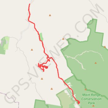
Interactive trail map
Trail profile
- Distance: 28.4 mi
- Elevation gain: 2,057 ft
- Maximum elevation: 1,867 ft
- Elevation loss: 2,421 ft
- Minimum elevation: 725 ft
- Moving time: 2 h 35 m
- Moving speed: 10.9 mph
- Maximum speed: 46.4 mph
- Total time: 6 h 26 m
- Global speed: 4.4 mph
About this trail
Name: Black Duck trail, distance, elevation, map, profile, GPS track
Start: 111-Shit Creek, East Haldon, Lockyer Valley Regional, Queensland, Australia (-27.84969 152.21060)
Coordinates: -27.88900 152.18743 -27.78339 152.24852
Other hiking, mountain biking, running and outdoor activity trails
Click on a trail to view its statistics, map and profile.
Warwick - Gatton
Australia > Queensland > Warwick
#Bike
Distance: 77.8 mi • Elevation gain: 2,664 ft • Maximum elevation: 1,909 ft
Walk to Glen Rock, QLD
Distance: 3.1 mi • Elevation gain: 1,519 ft • Maximum elevation: 2,582 ft
Black Duck
Distance: 8.7 mi • Elevation gain: 2,028 ft • Maximum elevation: 1,470 ft